Approximate Location Map
Large Map »
Latitude: 52.2849 / 52°17'5"N
Longitude: -2.1006 / 2°6'2"W
OS Eastings: 393233
OS Northings: 265201
OS Grid: SO932652
Mapcode National: GBR 2GG.PQQ
Mapcode Global: VH929.JTVR
Plus Code: 9C4V7VMX+XQ
Entry Name: Astwood Manor Farmhouse
Listing Date: 29 December 1952
Grade: II
Source: Historic England
Source ID: 1288254
English Heritage Legacy ID: 400128
ID on this website: 101288254
Location: Astwood, Wychavon, Worcestershire, B60
County: Worcestershire
District: Wychavon
Civil Parish: Dodderhill
Traditional County: Worcestershire
Lieutenancy Area (Ceremonial County): Worcestershire
Church of England Parish: Stoke Prior, Wychbold and Upton Warren
Church of England Diocese: Worcester
Tagged with: Farmhouse
DODDERHILL CP ASTWOOD LANE (south side)
SO 96 NW
SO 933652
6/5 Astwood Manor Farmhouse
29.12.52
GV II
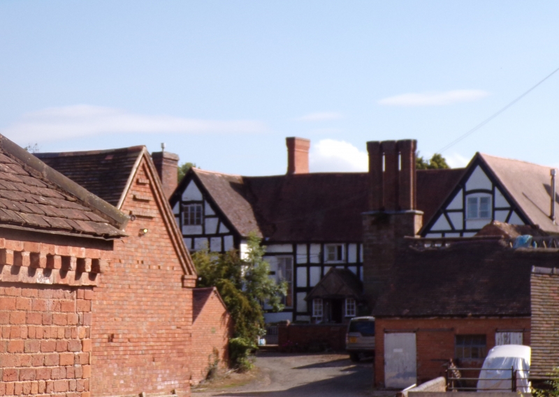
Farmhouse. Early C17, partly rebuilt late C18, with later repairs. Timber-
frame with painted brick infill, partly painted brick. H-plan, hall range
aligned north-west/south-east; south-east cross-wing rebuilt in late C18;
large lateral stone stack on south-west wall of hall, and stack on north-
west wall of north-west cross-wing, each with three star-plan shafts of
brick, rebuilt mid-C20; entrance roughly central with cross-passage, hall to
south-east side. South-west front: two storeys, attics to cross-wings;
irregular fenestration, 1:2:1 windows, 3-light C20 casement to left, tall
transomed 2-light stair window to left; 3-light casement under segmental
head. Entrance through central mid-C20 gabled porch, door flanked by fixed
casements. Framing: north-west cross-wing: two rectangular panels high to
ground floor, three high with tension braces to first floor; hall: four
rectangular panels high; some decorative framing to north-east (garden) front
of north-west cross-wing. Interior: single-flight stair with landing
balustrade of late C17 splat balusters. Remains of moat to west of farmhouse.
Listing NGR: SO9323365201
External links are from the relevant listing authority and, where applicable, Wikidata. Wikidata IDs may be related buildings as well as this specific building. If you want to add or update a link, you will need to do so by editing the Wikidata entry.


Other nearby listed buildings
