Approximate Location Map
Large Map »
Latitude: 51.4945 / 51°29'40"N
Longitude: 0.07 / 0°4'12"E
OS Eastings: 543795
OS Northings: 179312
OS Grid: TQ437793
Mapcode National: GBR NJ.JBV
Mapcode Global: VHHNK.5PCQ
Plus Code: 9F32F3VC+Q2
Entry Name: Royal Arsenal Building 41 and 41A Royal Laboratory Square
Listing Date: 26 July 1990
Last Amended: 9 July 1997
Grade: II
Source: Historic England
Source ID: 1288913
English Heritage Legacy ID: 398180
ID on this website: 101288913
Location: Royal Arsenal West, Greenwich, London, SE18
County: London
District: Greenwich
Electoral Ward/Division: Woolwich Riverside
Parish: Non Civil Parish
Built-Up Area: Greenwich
Traditional County: Kent
Lieutenancy Area (Ceremonial County): Greater London
Church of England Parish: Woolwich St Mary Magdalene with St Michael and All Angels
Church of England Diocese: Southwark
Tagged with: Architectural structure
TQ 4479 PLUMSTEAD ROAD SE18
(North side)
786/9/369 Royal Arsenal
Building 41 and 41A (Royal
Laboratory Square)
26/07/90
GV II
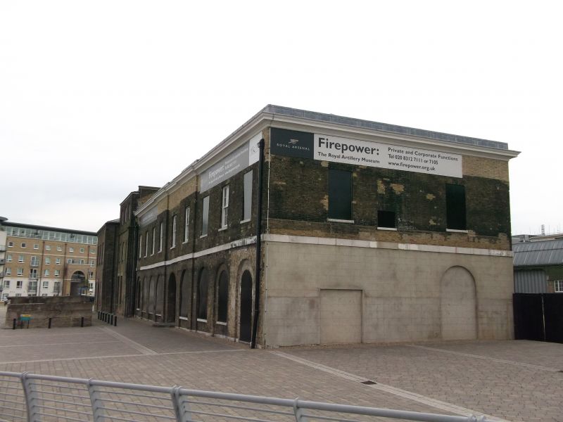
Ordnance factory and workshop, ammunition factory (1854), then sawmill and cooperage. West range of c1805, east and north ranges of c1810; cast-iron columns in east range inserted c1854; south range built as a carpenter's workshop, in 3 phases from 1878 and dating from the factory's function in the later C19 as a factory for the packing of ammunition into boxes and barrels. East, north and west ranges of Flemish bond yellow stock brick with Portland stone plat bands, cornicing and dressings; hipped slate and felt roofs.
Quadrangular plan, originally open to south.
EXTERIOR: EAST RANGE: 2 storeys; 15:5-window range. Symmetrical E elevation with slight projecting pedimented 5-window range to centre with a plat band and moulded eaves cornice running into the pediment. Ground floor of round-arched cast-iron windows set in round-arched recesses and partly blocked central archway through to the quadrangle; flat arches over 12-pane first-floor sashes; similar rear elevation. Right-hand (north) parapetted 1854 former beam engine house extension in similar style without Portland string, has taller ground-floor windows, blind to the centre (in position of beam support); 3-window return. To the rear (W) is the 3-storey; 2-window former boiler house, with flat-headed 6/6-pane sashes. Other beam engine house of 1854 to south end demolished.
NORTH RANGE: originally of 2 storeys, heightened by addition of upper storey in mock timber frame in early C20; similar 9-window elevations, but without pediment and refenestrated in early C20; interior, gutted in early C20, has lateral spine wall.
WEST RANGE: the pedimented east elevation faces into the courtyard and is identical to the facing west elevation of the east range; the ground floor of the west elevation has been rebuilt and rendered in mid C20; the interior gutted with internal concrete frame.
SOUTH RANGE (41A): cast-iron frame with brick infill, corrugated iron sheet cladding and corrugated sheet N-light roof. Rectangular plan with parallel ranges of arcades, the central 2 bays of 1878, 2-bay wide extension of c1890 on N side and 2-bay wide extension of c1900-31 on S side. Exposed iron frame of octagonal columns with small capitals, top section bolted to 2-ply longitudinal beams with quadrant curved ends and openwork spandrels; 2 octagonal sockets in the upper sides connect to N-light trusses with wrought-iron bars, and holes in the lower side for supports to the former line shafting.
INTERIOR of east range has an inserted 1854 arcade of cast-iron columns with flanged capitals on ground and first floors, supporting mid-C19 queen post trusses. West and north ranges have no surviving features of interest, having been remodelled in early and mid C20. South range has exposed iron frame of octagonal columns with small capitals, top section bolted to 2-ply longitudinal beams with quadrant curved ends and openwork spandrels; 2 octagonal sockets in the upper sides connect to north-light trusses with wrought-iron bars, and holes in the lower side for supports to the former line shafting.
HISTORICAL NOTE: Sited to the north of the original Royal Laboratory buildings of 1694-6, the quadrangle forming the New Laboratory Extensions was built for manufacturing gun powder, ammunition and fuses. As such, the quadrangular layout (originally open to the south) represents a significant surviving example of a large industrial layout of this period: although heightened in the early C20, the north range has retained substantially complete elevations up to the former cornice level, and the west range is particularly notable for the pedimented east elevation which faces into the courtyard and complements that of the east range. The east range is the most complete and retains important evidence of the group's conversion to steam power for manufacturing ammunition in 1854. The iron-framed ranges to the south represent an integral part of the factory's expansion in the later C19.
(RCHME report, 1994)
Listing NGR: TQ4379579312
External links are from the relevant listing authority and, where applicable, Wikidata. Wikidata IDs may be related buildings as well as this specific building. If you want to add or update a link, you will need to do so by editing the Wikidata entry.


Other nearby listed buildings
