Approximate Location Map
Large Map »
Latitude: 54.8962 / 54°53'46"N
Longitude: -2.9353 / 2°56'6"W
OS Eastings: 340114
OS Northings: 556121
OS Grid: NY401561
Mapcode National: GBR 7CYT.BM
Mapcode Global: WH802.W6FB
Plus Code: 9C6VV3W7+FV
Entry Name: 17, Scotch Street
Listing Date: 11 April 1994
Grade: II
Source: Historic England
Source ID: 1291901
English Heritage Legacy ID: 386846
ID on this website: 101291901
Location: Carlisle, Cumberland, Cumbria, CA3
County: Cumbria
District: Carlisle
Parish: Non Civil Parish
Built-Up Area: Carlisle
Traditional County: Cumberland
Lieutenancy Area (Ceremonial County): Cumbria
Church of England Parish: Carlisle St Cuthbert with St Mary
Church of England Diocese: Carlisle
Tagged with: Building
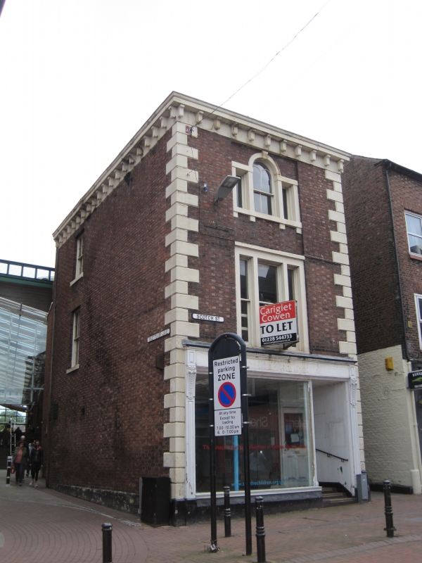
CARLISLE
NY4056SW SCOTCH STREET
671-1/8/258 (East side)
No.17
GV II
House, now shop with storage accommodation over. Early C19
with later alterations. Flemish bond brickwork with light
headers, on chamfered plinth (all dressings of painted stone)
with V-jointed quoins and bracketed cornice carried round the
left return. Hipped graduated greenslate roof without
chimneys.
3 storeys, single bay extending to rear; long narrow building
of double depth. Early C20 door and shop window on ground
floor, under overall signboard on carved wooden brackets.
Tripartite window above and Venetian window on 2nd floor, both
in stone surrounds and 2nd floor window with bracketed sill.
Plain brick right return faces onto Longcakes Lane. Left
return, facing onto East Tower Street, has 2 sash windows,
with glazing bars, one above the other, at the left, in brick
reveals. Evidence of ground-floor windows infilled with brick.
INTERIOR not inspected.
HISTORY: Although this is at the end of the present Scotch
Street and this house would be expected to be No.1, originally
the street extended `without' the city as far as Drovers Lane
where Rickergate started. The reason was that the city
boundary was marked by the ditch and when this was infilled
the boundary remained outside the walls. For the restoration
of the buildings, with illustrations, see Cumberland News
(1981).
(Cumberland News: 12 June 1981: P.14).
Listing NGR: NY4011456121
External links are from the relevant listing authority and, where applicable, Wikidata. Wikidata IDs may be related buildings as well as this specific building. If you want to add or update a link, you will need to do so by editing the Wikidata entry.


Other nearby listed buildings
