Approximate Location Map
Large Map »
Latitude: 54.1554 / 54°9'19"N
Longitude: -3.186 / 3°11'9"W
OS Eastings: 322641
OS Northings: 473934
OS Grid: SD226739
Mapcode National: GBR 6N6D.05
Mapcode Global: WH72B.1T39
Plus Code: 9C6R5R47+5H
Entry Name: Number 6 with Attached Front Garden Wall
Listing Date: 6 May 1976
Last Amended: 20 December 1993
Grade: II
Source: Historic England
Source ID: 1292014
English Heritage Legacy ID: 388502
ID on this website: 101292014
Location: Dalton-in-Furness, Westmorland and Furness, Cumbria, LA15
County: Cumbria
District: Barrow-in-Furness
Civil Parish: Dalton Town with Newton
Built-Up Area: Dalton-in-Furness
Traditional County: Lancashire
Lieutenancy Area (Ceremonial County): Cumbria
Church of England Parish: Dalton-in-Furness St Mary
Church of England Diocese: Carlisle
Tagged with: Building
BARROW IN FURNESS
SD2273 MARKET PLACE, Dalton In Furness
708-1/11/173 (South side)
06/05/76 No.6
with attached front garden wall
(Formerly Listed as:
MARKET PLACE, Dalton
Nos.6 AND 7)
GV II
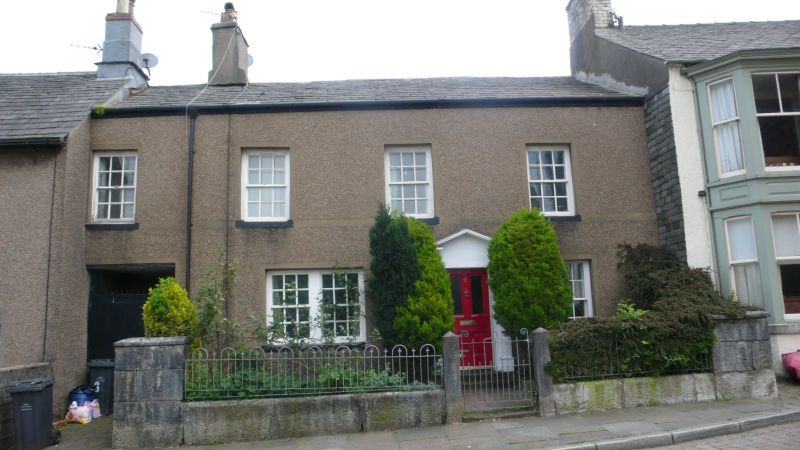
House and attached front garden wall. Early C18 core altered
early C19. Pebble-dashed stone, graduated slate roof (replaced
by composition tiles to rear). 2 storeys with attic; 4 windows
to 1st floor; wing to rear right. Doorway to right of centre
has part-glazed, 4-panel door in renewed wooden doorcase
having Doric columns and broken pediment. Stone sill to
16-pane sash on right otherwise projecting sills to 12-pane
sashes; twin sash on left of door. Bay 1 has wide passage
opening. Ridge stack to right of bay 1. INTERIOR: transverse
oak beams in body of house and in rear wing. Staircase with
half landing: square rods, barrel-turned newels and moulded
handrail. Some 2-pane doors to 1st floor. Front garden wall:
limestone; square gate piers, dwarf wall surmounted by later
railings, taller ends with copings return to adjoin house.
Once known as Rock House.
Listing NGR: SD2264173934
External links are from the relevant listing authority and, where applicable, Wikidata. Wikidata IDs may be related buildings as well as this specific building. If you want to add or update a link, you will need to do so by editing the Wikidata entry.


Other nearby listed buildings
