Approximate Location Map
Large Map »
Latitude: 52.189 / 52°11'20"N
Longitude: 0.999 / 0°59'56"E
OS Eastings: 605097
OS Northings: 258766
OS Grid: TM050587
Mapcode National: GBR SJM.MDX
Mapcode Global: VHKDP.87JR
Plus Code: 9F425XQX+HJ
Entry Name: The Maltings
Listing Date: 19 April 1972
Last Amended: 29 November 1993
Grade: II
Source: Historic England
Source ID: 1292516
English Heritage Legacy ID: 384641
ID on this website: 101292516
Location: Stowmarket, Mid Suffolk, IP14
County: Suffolk
District: Mid Suffolk
Civil Parish: Stowmarket
Built-Up Area: Stowmarket
Traditional County: Suffolk
Lieutenancy Area (Ceremonial County): Suffolk
Church of England Parish: Stowmarket St Peter and St Mary
Church of England Diocese: St.Edmundsbury and Ipswich
Tagged with: Architectural structure
STOWMARKET
TM0558 STATION ROAD
614-1/4/113 (South side)
19/04/72 The Maltings
(Formerly Listed as:
STATION ROAD
(South side)
Malthouse (Malga Products Limited))
GV II
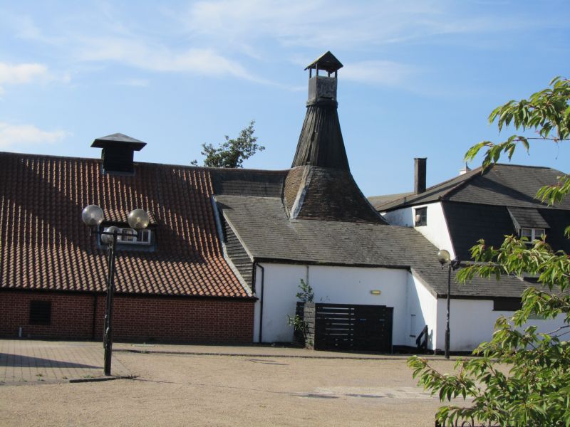
Malthouse, then warehouse, now restaurant and leisure centre.
Late C18 and later. Flint and brick under roofs of pantiles or
slate. L-shaped plan, the major arm running north-south, the
minor east-west, both terminating in a kiln with conical flue.
2 storeys and attics. At north end of long arm is the
restaurant. Whole flints with brick dressings and piers, one
storey and attic. Segmental-arched openings at intervals.
Mansard slate roof with two C20 sloping dormers to east and
west faces. Immediately south is the kiln with its louvred
conical flue and, to the east a long outshut.
East face of the main range with a deep outshut to the
pantiled roof extending to the ground level.
West side of 2 storeys and dormer attic. Whitewashed brick.
Ground floor with 9 openings for loading shutes under
segmental heads, intended for barges on adjacent River
Gipping. One ground-floor entrance at south end and 2
first-floor loading doors flanked by irregular fenestration. 2
sloping dormers in roof.
East-west range has a large outshut attached to south side.
Half-hipped roof at east end. Attached to north of east end is
a square malting kiln with a tall pyramid roof on a
single-storey whitewashed brick plinth. Louvre at apex. To the
right the east-west range has various windows, a loading lucam
and 2 sloping dormers.
INTERIOR. Square post construction with tie beams on straight
braces. No original equipment or fittings remain.
Listing NGR: TM0509758766
External links are from the relevant listing authority and, where applicable, Wikidata. Wikidata IDs may be related buildings as well as this specific building. If you want to add or update a link, you will need to do so by editing the Wikidata entry.


Other nearby listed buildings
