Approximate Location Map
Large Map »
Latitude: 52.5871 / 52°35'13"N
Longitude: -0.7226 / 0°43'21"W
OS Eastings: 486639
OS Northings: 299578
OS Grid: SP866995
Mapcode National: GBR CSK.XSL
Mapcode Global: WHFL1.W72H
Plus Code: 9C4XH7PG+RX
Entry Name: Churchyard Wall
Listing Date: 15 October 1984
Grade: II
Source: Historic England
Source ID: 1295044
English Heritage Legacy ID: 186816
ID on this website: 101295044
Location: Uppingham, Rutland, LE15
County: Rutland
Civil Parish: Uppingham
Built-Up Area: Uppingham
Traditional County: Rutland
Lieutenancy Area (Ceremonial County): Rutland
Church of England Parish: Uppingham St Peter and St Paul
Church of England Diocese: Peterborough
Tagged with: Churchyard wall
SP 8699-8799 UPPINGHAM LONDON ROAD
4/78 (east side)
Churchyard Wall
GV
II
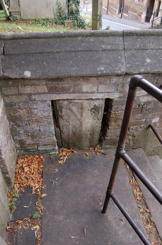
Wall. C18 and later but incorporating mediaeval fragments. Squared stone with
coping. Two blocked cambered-headed openings (originally recesses in which
pedestrians could shelter from traffic). Part of wall framing steps up into
churchyard incorporates 4 fragments from mediaeval coffin lids.
Listing NGR: SP8663999578
External links are from the relevant listing authority and, where applicable, Wikidata. Wikidata IDs may be related buildings as well as this specific building. If you want to add or update a link, you will need to do so by editing the Wikidata entry.


Other nearby listed buildings
