Approximate Location Map
Large Map »
Latitude: 51.6763 / 51°40'34"N
Longitude: 0.3204 / 0°19'13"E
OS Eastings: 560531
OS Northings: 200050
OS Grid: TL605000
Mapcode National: GBR YC.TPX
Mapcode Global: VHHMX.H4Q9
Plus Code: 9F32M8GC+G4
Entry Name: Hay Green Farmhouse
Listing Date: 9 December 1994
Grade: II
Source: Historic England
Source ID: 1297288
English Heritage Legacy ID: 373327
ID on this website: 101297288
Location: Brentwood, Essex, CM4
County: Essex
District: Brentwood
Civil Parish: Blackmore, Hook End and Wyatts Green
Traditional County: Essex
Lieutenancy Area (Ceremonial County): Essex
Church of England Parish: Blackmore St Laurence
Church of England Diocese: Chelmsford
Tagged with: Farmhouse
BLACKMORE
TL60SW HAY GREEN LANE
723-1/2/23 (North West side)
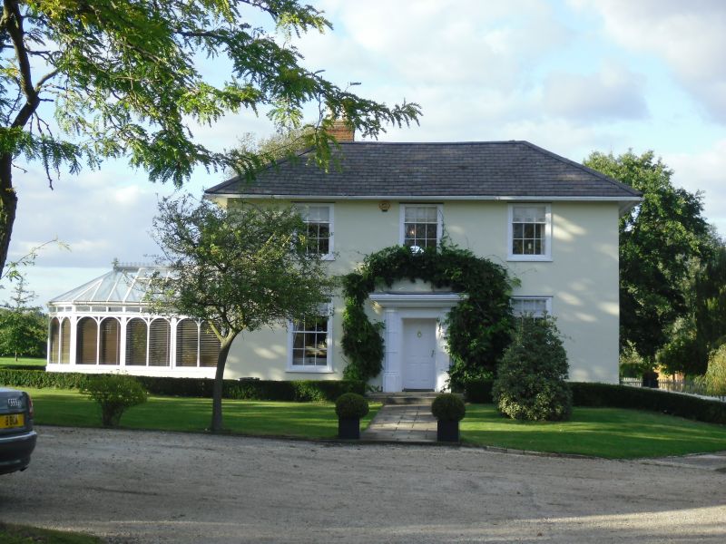
Hay Green Farmhouse
GV II
House. c1800, extended in C19 and C20. Timber-framed,
plastered, roofed with slate. Double range forming a square
plan facing S. Internal chimney between ranges at left,
external chimney to rear left. Conservatory with apsidal end
to left. C19 lean-to to rear left, enclosing stack; C20 lean
to to rear right, leaving central space between.
2 storeys. 2 sashes of 6+6 lights on ground floor, 3 of 3+6
lights on first floor, all with reeded architraves. Central
recessed half-glazed door; doorcase with 2 Gothic attached
columns with moulded bases, caps and bands, and flat canopy
with band of Greek key ornament. Low-pitched roof with 4 hips
and long overhanging eaves, reported to be of lead until
stolen about 1970. The left elevation has one ground-floor
window and one first-floor window similar to those at front.
The right elevation has 2 of each, similar. The rear elevation
has on the first floor a central sash with semicircular head
and 2 half-round pilasters.
INTERIOR: original stair with pine handrail, and turned newel,
and stick balusters. Shown in highway diversion map of 1810 as
Grays Gate.
(Essex Record Office: Q/RHI 3/63).
Listing NGR: TL6055100023
External links are from the relevant listing authority and, where applicable, Wikidata. Wikidata IDs may be related buildings as well as this specific building. If you want to add or update a link, you will need to do so by editing the Wikidata entry.


Other nearby listed buildings
