Approximate Location Map
Large Map »
Latitude: 52.596 / 52°35'45"N
Longitude: -1.687 / 1°41'13"W
OS Eastings: 421298
OS Northings: 299841
OS Grid: SP212998
Mapcode National: GBR 5HB.6B3
Mapcode Global: WHCHB.10YP
Plus Code: 9C4WH8W7+96
Entry Name: Cruck Barn
Listing Date: 22 July 1953
Last Amended: 28 February 1992
Grade: II
Source: Historic England
Source ID: 1297345
English Heritage Legacy ID: 386450
ID on this website: 101297345
Location: Dosthill, Tamworth, Staffordshire, B77
County: Staffordshire
District: Tamworth
Electoral Ward/Division: Trinity
Parish: Non Civil Parish
Built-Up Area: Tamworth
Traditional County: Warwickshire
Lieutenancy Area (Ceremonial County): Staffordshire
Church of England Parish: Dosthill
Church of England Diocese: Birmingham
Tagged with: Barn
TAMWORTH
SP29NW CHURCH ROAD, Dosthill
670-1/5/23 (East side)
22/07/53 Cruck Barn
(Formerly Listed as:
Barn at Church House Farm)
GV II
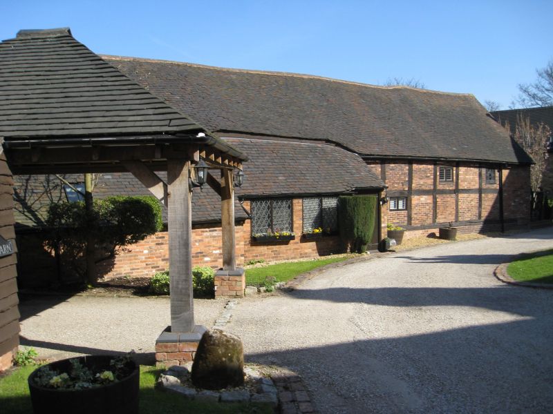
Barn, now converted and empty (1990). C15/C16. Timber-framed
with brick infill; tile roof. 4-bay cruck construction with
rear outshut. Square framing on rubble plinth with outshut
under catslide roof to left end; former threshing-floor
entrance has C20 infill and porch under catslide roof,
wide-boarded inner door; some inserted windows. Left return
has exposed cruck truss with cruck spurs and short king post
on yoke; right return has brick replacing cruck truss. Rear:
continuous outshut with C20 alterations to left with raised
eaves; central threshing-floor entrance with paired doors;
right end further outshut with 4 openings revealing inner
timber framing, small gabled dormer above. Interior: cruck
trusses with braced collars, cruck spurs and wind braces; one
truss with C20 brick infill.
(Trans. of S. Staffordshire Archaeological & Historical
Society: A Four-bay Cruck Barn with Outshut at Dosthill,
Tamworth, Staffs: 1972-1973: 45FF).
Listing NGR: SP2129899841
External links are from the relevant listing authority and, where applicable, Wikidata. Wikidata IDs may be related buildings as well as this specific building. If you want to add or update a link, you will need to do so by editing the Wikidata entry.


Other nearby listed buildings
