Approximate Location Map
Large Map »
Latitude: 52.9002 / 52°54'0"N
Longitude: -2.1449 / 2°8'41"W
OS Eastings: 390349
OS Northings: 333654
OS Grid: SJ903336
Mapcode National: GBR 15Q.4KD
Mapcode Global: WHBDF.0CWG
Plus Code: 9C4VWV24+32
Entry Name: The Moorings (former warehouse and cottage adjoining the Trent and Mersey Canal)
Listing Date: 23 June 1986
Last Amended: 15 August 2023
Grade: II
Source: Historic England
Source ID: 1297501
English Heritage Legacy ID: 386034
ID on this website: 101297501
Location: Stone, Stafford, Staffordshire, ST15
County: Staffordshire
District: Stafford
Civil Parish: Stone
Built-Up Area: Stone
Traditional County: Staffordshire
Lieutenancy Area (Ceremonial County): Staffordshire
Church of England Parish: Stone St Michael and St Wulfad
Church of England Diocese: Lichfield
Tagged with: Former warehouse
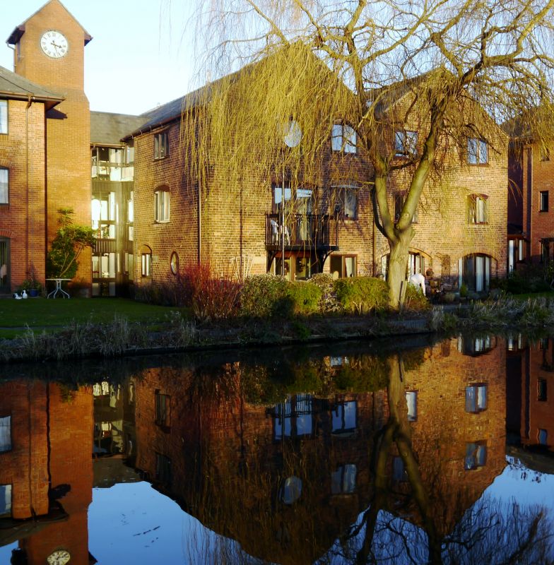
A late-C18 warehouse with C19 additions.
A late-C18 warehouse with C19 additions.
MATERIALS: brick walls, slate roofs.
PLAN: the warehouse is two adjoining, narrow rectangular ranges orientated north-east / south-west (referred to as north / south for clarity). The north elevation of the western range runs diagonally south-west from where it joins the east range, while the eastern range’s north elevation is horizontal, parallel with the southern elevations. A late-C19 addition, square in plan, adjoins the eastern range in the centre of its east elevation.
EXTERIOR: all doors and windows are from the late-C20 and early-C21. The warehouse was built in two parallel long rectangular ranges, each of three stories. The ranges are under pitched roofs with gables to north and south, forming an ‘M’ shape roof. The eastern range is the earliest, dating to the late-C18, and the western range dates to the early-C19. Both ranges are in brick in English garden wall bond, though the eastern range has four stretcher courses between the header courses, and the west range three stretcher courses. Older openings are under segmental arched brick lintels, with smaller openings having a single rowlock course, larger openings having a second rowlock course alternated with soldiers, and the largest having arches three rowlock courses in height, alternating between rowlock over soldier and soldier over rowlock. The side elevations have a dentil detail at eaves level and are interrupted by the link to the late-C20 flats to the west and the late-C19 square plan addition to the east.
The south elevation faces the canal and here the west range has centrally located openings to each of its three floors; the ground and first floors are tall windows, extended from earlier shorter openings, and there is a circular window at second floor level. All three of these openings have had a new window inserted to their east. The south elevation of the adjoining east range has an arched boat-hole (now French doors) to its west at ground floor level. A second arched opening has been inserted to the east of the boat access. At first-floor level are two windows in their original locations. At second-floor level, an older central window has been infilled, and two new windows inserted, one either side of the blocked opening. The northern return of the west range has a circular window at ground floor level, with blocked and new openings similar to other elevations. The east range’s return to the north again shows blocked and altered openings.
Both ranges of the rear, north, elevation have two openings to each of their three floors. There is evidence of rearrangement of doors and windows; both ranges have a central blocked opening to the ground floor, and an opening in the gable of the east range has been infilled incorporating projecting bricks for bird perches and (now blocked) roost holes. The north elevation of the west range accentuates its join with the east by being angled to the south, away from the horizontal line that the east range takes here. The southern returns of both ranges display the same type of altered openings as in the rest of the warehouse, with there being a circular opening at the ground floor level of the west range.
A three-storey, late-C19 square-plan addition under a pyramidal roof is built against the east side of the warehouse. It is brick in English bond. The top brick course of headers slightly projects. Its south elevation is set back from the line of the warehouse to the west, and here it has had its external ground floor wall removed and a conservatory added (the conservatory is not included in the listing). There is a single horizontal window to the second floor. The rear, north elevation is divided into three bays with a window or door in each bay at each of the three floors. This elevation shows evidence that some of the openings are new or altered insertions, and concrete lintels have been inserted over the central openings to the ground and first floors. The side, eastern elevation has a blocked doorway and several new windows.
INTERIOR: there are 12 flats in the two ranges of the warehouse, arranged with two flats per range to each of the three floors. The different floors are accessed by a staircase which is located in the late-C20 flats to the west.
The interiors on all floors display deep window reveals and chamfered beams to the ceilings. The third-floor flats and communal areas show that the respective roof trusses of both ranges are aligned at the gables, but are set at differing intervals moving along the length of the roof. The trusses in the earlier, late-C18 eastern range have a king post with three pairs of struts running diagonally up from it to the rafters. The trusses in the early-C19 western range have king posts with one pair of struts running from near the base of the king post to near the top of the rafter, and the other pair between the tie beam and bottom of the principal rafter. The rafters to the trusses in both ranges carry two purlins each.
The late-C19 square-plan addition under a pyramidal roof is now three flats (one to each floor), with a residents’ lounge in the ground floor conservatory. The subdivision into separate dwellings has obscured the original fabric, though the top floor flat has one exposed beam with the presence of other beams suggested by plasterboard boxing. Some of the hip rafters which form the pyramidal roof can be seen in the communal areas of the top floor.
The Moorings is a development of flats located alongside the Trent and Mersey Canal in Stone’s town centre. The site is just north of a former wharf on the canal-side. The complex consists of a canal-side warehouse and part of the former wharf-keepers cottage; these two older buildings are connected through late-C20 additions. This List entry only covers the central pre-C20 warehouse elements. The canal opened in 1777 and the cottage is likely of similar date. The warehouse is two adjoining ranges; the eastern range being close in date with the canal, and the western dating to the early-C19.
Both warehouse and cottage appear on the 1880 Ordnance Survey map where a branch of the canal is shown running into the warehouse building. Subsequent maps and photographs show that the warehouse was extended to its east at the end of the C19, then to the west sometime between 1929 and 1937. The site was purchased in 1955 from the British Transport Commission by Stubbs & Co, a local corn merchants and grain millers. A photograph from 1989 shows the western addition to have been a large wooden grain store raised on stilts from the ground and displaying signage for Stubbs and Co. Later in the C20 the site was used for storing building materials. In the late-1980s the wooden grain store and part of the cottage were demolished, the warehouse and remaining part of the cottage were converted to flats, and new purpose-built blocks of flats were added linking the older buildings.
The Moorings (former warehouse adjoining the Trent and Mersey Canal), Stone, is listed at Grade II for the following principal reasons:
Architectural interest:
* the building survives well as a good example of a canal-side warehouse with a good proportion of its historic fabric surviving;
* the building retains features such as circular openings and a boat-hole allowing it to be readily identified as a canal-side warehouse.
Historic interest:
* the warehouse is evidence of the importance of transport using inland waterways in stimulating local industry and contributing to the progress of the Industrial Revolution
Group value:
* the Moorings is in close proximity to another near contemporary warehouse, a canal lock and canal milepost; together they illustrate Stone’s history as an inland port.
External links are from the relevant listing authority and, where applicable, Wikidata. Wikidata IDs may be related buildings as well as this specific building. If you want to add or update a link, you will need to do so by editing the Wikidata entry.


Other nearby listed buildings
