Approximate Location Map
Large Map »
Latitude: 53.0026 / 53°0'9"N
Longitude: -2.1866 / 2°11'11"W
OS Eastings: 387577
OS Northings: 345049
OS Grid: SJ875450
Mapcode National: GBR MJL.75
Mapcode Global: WHBCT.DS0H
Plus Code: 9C5V2R37+29
Entry Name: Mile Post
Listing Date: 15 March 1993
Grade: II
Source: Historic England
Source ID: 1297962
English Heritage Legacy ID: 384433
ID on this website: 101297962
Location: Stoke-upon-Trent, Stoke-on-Trent, Staffordshire, ST4
County: City of Stoke-on-Trent
Electoral Ward/Division: Penkhull and Stoke
Parish: Non Civil Parish
Built-Up Area: Stoke-on-Trent
Traditional County: Staffordshire
Lieutenancy Area (Ceremonial County): Staffordshire
Church of England Parish: Stoke upon Trent and Fenton
Church of England Diocese: Lichfield
Tagged with: Milestone
STOKE ON TRENT
SJ8645 LONDON ROAD
613-1/9/135 (North West side)
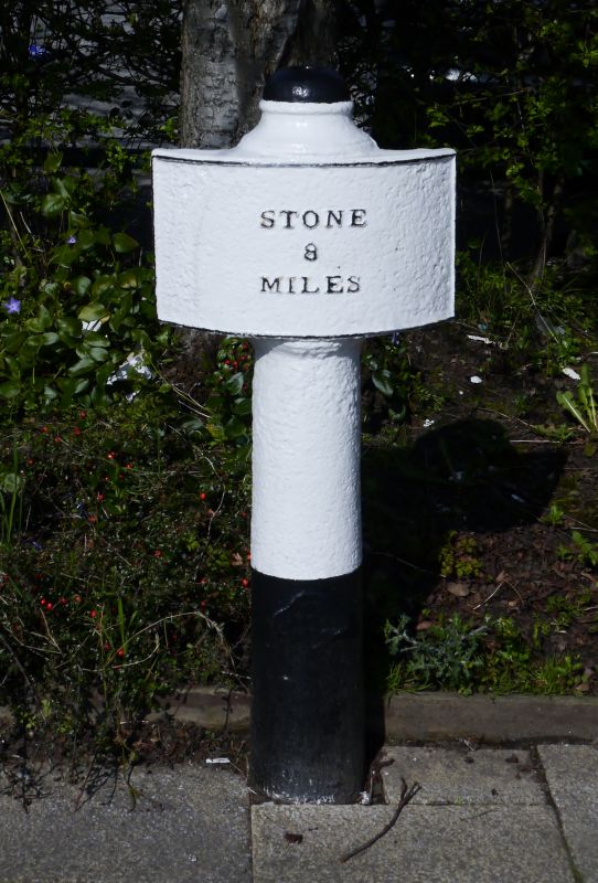
Mile Post
GV II
Mile Post. Early C19. Cast-iron. Cylindrical shaft with domed
cap and panel with raised lettering, "Stone 8 Miles".
Listing NGR: SJ8757745049
External links are from the relevant listing authority and, where applicable, Wikidata. Wikidata IDs may be related buildings as well as this specific building. If you want to add or update a link, you will need to do so by editing the Wikidata entry.


Other nearby listed buildings
