Approximate Location Map
Large Map »
Latitude: 54.0499 / 54°2'59"N
Longitude: -2.8024 / 2°48'8"W
OS Eastings: 347563
OS Northings: 461844
OS Grid: SD475618
Mapcode National: GBR 8PWL.2Z
Mapcode Global: WH846.XGQN
Plus Code: 9C6V25XX+X2
Entry Name: Sun Inn
Listing Date: 13 March 1995
Grade: II
Source: Historic England
Source ID: 1298411
English Heritage Legacy ID: 383111
Also known as: Sun
The Sun, Lancaster City Centre, Lancaster
The Sun Hotel & Bar
ID on this website: 101298411
Location: Lancaster, Lancashire, LA1
County: Lancashire
District: Lancaster
Electoral Ward/Division: Castle
Parish: Non Civil Parish
Built-Up Area: Lancaster
Traditional County: Lancashire
Lieutenancy Area (Ceremonial County): Lancashire
Church of England Parish: Lancaster St Mary with St John and St Anne
Church of England Diocese: Blackburn
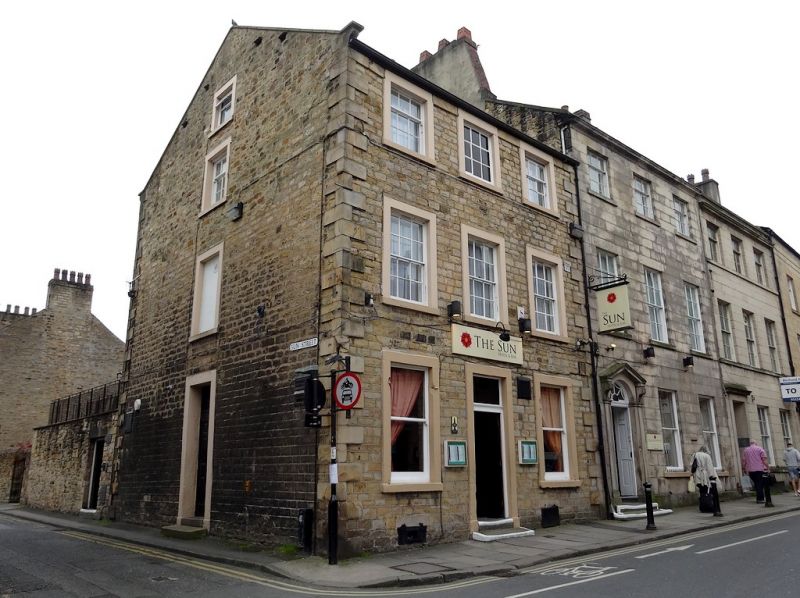
LANCASTER
SD4761NE CHURCH STREET
1685-1/7/79 (South side)
No.63
Sun Inn
GV II
Public house. Late C18, altered C19. Coursed squared sandstone
with ashlar dressings on the front and side, but rendered
rubble elsewhere. Slate roof with a coped gable with kneelers
to the left. Double-depth front block with a central doorway
and a rear wing to the right.
3 storeys above cellars and 3 bays with raised plain quoins.
All the openings have raised plain surrounds. The doorway has
double doors of uncertain vintage with 10 flush panels. All
the windows are sashed: those on the ground floor have no
glazing bars; those on the first and second floors have 12 and
9 panes respectively; in the central bay on the second floor a
glazed 9-pane blind window. The left-hand gable has a central
doorway on the ground floor, with a window placed above it in
each of the floors above, the first floor one is now blocked.
In the rear wing close to the main block is a tall staircase
window.
HISTORY: built as part of the redevelopment of the land behind
the old Sun Inn in the 1790s, which also resulted in the
laying out of Sun Street.
Listing NGR: SD4756361844
External links are from the relevant listing authority and, where applicable, Wikidata. Wikidata IDs may be related buildings as well as this specific building. If you want to add or update a link, you will need to do so by editing the Wikidata entry.


Other nearby listed buildings
