Approximate Location Map
Large Map »
Latitude: 51.4564 / 51°27'23"N
Longitude: -2.5974 / 2°35'50"W
OS Eastings: 358589
OS Northings: 173216
OS Grid: ST585732
Mapcode National: GBR C7J.JR
Mapcode Global: VH88M.XNQD
Plus Code: 9C3VFC43+H2
Entry Name: 62, Colston Street
Listing Date: 2 April 1973
Last Amended: 30 December 1994
Grade: II
Source: Historic England
Source ID: 1298803
English Heritage Legacy ID: 379349
ID on this website: 101298803
Location: Bristol, BS1
County: City of Bristol
Electoral Ward/Division: Central
Parish: Non Civil Parish
Built-Up Area: Bristol
Traditional County: Gloucestershire
Lieutenancy Area (Ceremonial County): Bristol
Church of England Parish: Bristol St Stephen with St James and St John the Baptist with St Michael and St George
Church of England Diocese: Bristol
Tagged with: Building
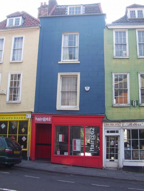
BRISTOL
ST5873SE COLSTON STREET
901-1/11/81 (East side)
02/04/73 No.62
(Formerly Listed as:
COLSTON STREET
(East side)
Nos.62-66 (Even))
GV II
Attached house, now shop and office. Early C18. Stuccoed
timber-frame with a left-hand brick stack and pantile hipped
mansard roof. Single rooms front and back with central
left-hand stair. 3 storeys, attic and basement; 1-window
range. C19 shop front and a moulded eaves cornice. Central
recessed doorway has a 2-panel door with strap hinges, reeded
transom and a panel above with a medallion, fascia and cornice
and plate-glass windows; 6/6-pane sashes in flush first-floor
frame, recessed above, and a hipped dormer with casements with
glazing bars. INTERIOR not inspected.
Listing NGR: ST5858973216
External links are from the relevant listing authority and, where applicable, Wikidata. Wikidata IDs may be related buildings as well as this specific building. If you want to add or update a link, you will need to do so by editing the Wikidata entry.


Other nearby listed buildings
