Approximate Location Map
Large Map »
Latitude: 55.0104 / 55°0'37"N
Longitude: -1.4331 / 1°25'59"W
OS Eastings: 436355
OS Northings: 568574
OS Grid: NZ363685
Mapcode National: GBR LBFH.JQ
Mapcode Global: WHD4R.YBR9
Plus Code: 9C7W2H68+5Q
Entry Name: Ballard's Smoke House Clifford's Fort and Boundary Stones Attached
Listing Date: 19 February 1986
Grade: II
Source: Historic England
Source ID: 1299778
English Heritage Legacy ID: 303381
ID on this website: 101299778
Location: North Shields, North Tyneside, Tyne and Wear, NE30
County: North Tyneside
Electoral Ward/Division: Tynemouth
Parish: Non Civil Parish
Built-Up Area: Tynemouth
Traditional County: Northumberland
Lieutenancy Area (Ceremonial County): Tyne and Wear
Church of England Parish: Tynemouth Priory Holy Saviour
Church of England Diocese: Newcastle
Tagged with: Architectural structure Military building
TYNEMOUTH UNION ROAD (east side, off)
NZ 3668 NW
North Shields.
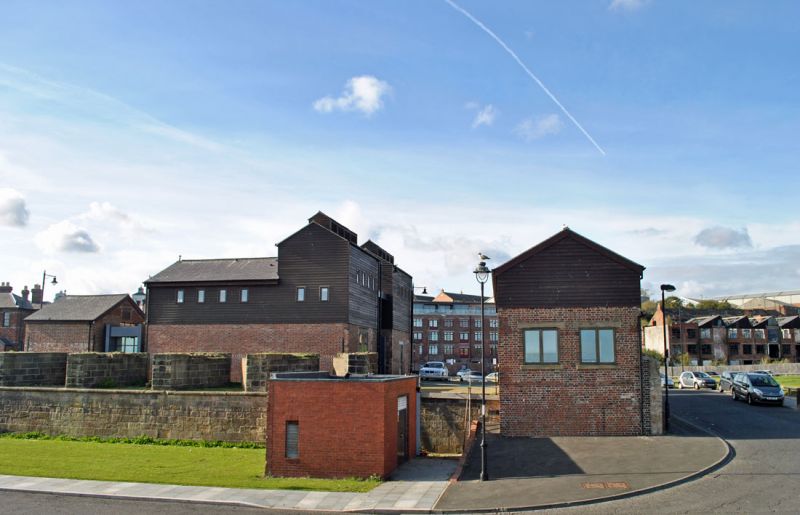
13/133 Clifford's Fort (No. 9)
(Ballard's Smoke House) and
boundary stones attached.
G.V. II
Smoke house, formerly barracks building; 2 military fort boundary stones. Circa
1920 smoke house built on mid C19 military building; mid C19 boundary stones.
Smoke house: sandstone rubble rear lower courses, brick ground floor in varying
bonds with sandstone dressings; weatherboarded upper stages; Welsh slate roof.
2 storeys, 3 bays and 3 storeys one bay at right. Central sliding door; flat
stone lintel and projecting stone sill to blocked window at left ground floor;
weatherboarded first floor has horizontal sliding sashes; 3-storey section has
top-hung weatherboarded ventilator shutters. Long louvred ridge ventilator
has 4 tall ventilator stacks. Boundary stones: square blocks set in rubble
north wall, at about 1 1/2 metres above ground, inscribed WD/BS/No. 15; in west
face of north-west corner, about 150 cm above ground, inscribed WD/BS/No. 16:
Listing NGR: NZ3635568574
External links are from the relevant listing authority and, where applicable, Wikidata. Wikidata IDs may be related buildings as well as this specific building. If you want to add or update a link, you will need to do so by editing the Wikidata entry.


Other nearby listed buildings
