Approximate Location Map
Large Map »
Latitude: 53.3546 / 53°21'16"N
Longitude: -2.9969 / 2°59'48"W
OS Eastings: 333743
OS Northings: 384654
OS Grid: SJ337846
Mapcode National: GBR 7YHN.Z5
Mapcode Global: WH87D.YY25
Plus Code: 9C5V9233+R6
Entry Name: 14-16, Church Drive
Listing Date: 20 December 1965
Grade: II
Source: Historic England
Source ID: 1300428
English Heritage Legacy ID: 215371
Also known as: 14 - 16 Church Drive, Port Sunlight
14 - 16 Church Drive & 25 - 27 Windy Bank
ID on this website: 101300428
Location: Port Sunlight, Wirral, Merseyside, CH62
County: Wirral
Electoral Ward/Division: Bromborough
Parish: Non Civil Parish
Built-Up Area: Bebington
Traditional County: Cheshire
Lieutenancy Area (Ceremonial County): Merseyside
Church of England Parish: New Ferry St Mark
Church of England Diocese: Chester
Tagged with: Group of structures or buildings
BEBINGTON CHURCH DRIVE
SJ 3384 NE
(west side)
Port Sunlight
13/52 Nos. 14, 15
20.12.65 and 16
G.V. II
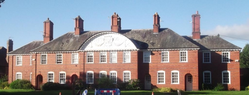
Includes Nos. 25, 26 and 27 Windy Bank. 6 houses. 1900-2.
By Grayson and Ould. Red brick with bands of blue brick,
hipped slate roofs. 2 storeys, 14 bays, 2 bays at each end
recessed, central 4 bays break forward under segmental
pediment. Top modillioned cornice; pediment has pargetting
with festoons, cartouche with "L" and date 1900. Angle
pilasters. Windows have sashes with glazing bars, those to
ground floor are segmental headed. Entrances in round-
headed recesses with keys; half-glazed doors with small-
paned lights. 5 cross-axial stacks with angle pilasters and
tile caps. Rear similar.
Listing NGR: SJ3374384654
External links are from the relevant listing authority and, where applicable, Wikidata. Wikidata IDs may be related buildings as well as this specific building. If you want to add or update a link, you will need to do so by editing the Wikidata entry.


Other nearby listed buildings
