Approximate Location Map
Large Map »
Latitude: 50.8378 / 50°50'15"N
Longitude: -0.9806 / 0°58'50"W
OS Eastings: 471879
OS Northings: 104743
OS Grid: SU718047
Mapcode National: GBR BCV.JWG
Mapcode Global: FRA 86TW.KSD
Plus Code: 9C2XR2Q9+4Q
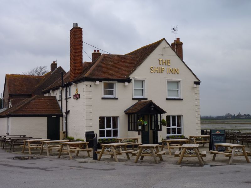
Entry Name: The Ship Inn
Listing Date: 21 July 1975
Last Amended: 6 February 1984
Grade: II
Source: Historic England
Source ID: 1303563
English Heritage Legacy ID: 135416
Also known as: Ship Inn
The Ship Inn, Langstone
ID on this website: 101303563
Location: Langstone, Havant, Hampshire, PO9
County: Hampshire
District: Havant
Electoral Ward/Division: St Faith's
Parish: Non Civil Parish
Built-Up Area: Havant
Traditional County: Hampshire
Lieutenancy Area (Ceremonial County): Hampshire
Church of England Parish: Havant St Faith
Church of England Diocese: Portsmouth
SU 70 SW HAVANT LANGSTONE
21.7.75 The Ship Inn
(formerly listed under
High Street)
7/6 II
Public house. C18, much restored. Painted brick walls (some stucco) and
tiled roof. 2 storeys, 6 windows to the long east elevation. Victorian
sashes. ½-glazed mid C19 porch.
Listing NGR: SU7192204560
External links are from the relevant listing authority and, where applicable, Wikidata. Wikidata IDs may be related buildings as well as this specific building. If you want to add or update a link, you will need to do so by editing the Wikidata entry.


Other nearby listed buildings
