Approximate Location Map
Large Map »
Latitude: 50.8034 / 50°48'12"N
Longitude: -1.9891 / 1°59'20"W
OS Eastings: 400867
OS Northings: 100430
OS Grid: SU008004
Mapcode National: GBR 31M.FYF
Mapcode Global: FRA 66QZ.2X5
Plus Code: 9C2WR236+99
Entry Name: 63, West Borough
Listing Date: 14 June 1952
Last Amended: 2 February 1983
Grade: II
Source: Historic England
Source ID: 1304037
English Heritage Legacy ID: 107174
ID on this website: 101304037
Location: Wimborne Minster, Dorset, BH21
County: Dorset
Civil Parish: Wimborne Minster
Built-Up Area: Wimborne Minster
Traditional County: Dorset
Lieutenancy Area (Ceremonial County): Dorset
Church of England Parish: Wimborne Minster St Cuthberga
Church of England Diocese: Salisbury
Tagged with: Building
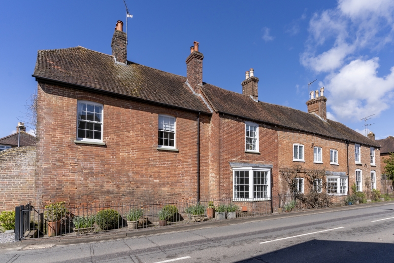
WEST BOROUGH
1.
5193
(west side)
No 63
(formerly listed
as No 30
SU 0000 1/150 14.6.52
II
2.
On corner of West Borough and Blind Lane. Of several builds. Early C18 origin,
enlarged in late C18 and C19. Brick walls, tiled roof, brick stacks. Two storeys.
Original centre section has platband at first floor level, and central doorway, now
altered to form a window. Ground floor has two 2-light casement windows with lead
lights and a later inserted canted bay window, with double hung sashes with glazing
bars. First floor has three 2-light casement windows with lead lights. A change in
the brickwork above the first floor windows suggests that the roof has been raised
here. The extension to the north has 2 double hung sash windows with arched heads
and glazing bars on the ground floor and one similar window on the first floor.
The first extension to the south has, on the ground floor, a canted bay window
similar to that in the centre section. The first floor has one double hung sash
window with glazing bars. The second extension to the south, of C19 date, has no
windows on the ground floor, but 2 double hung sash windows with glazing bars on
the first floor. At the rear, the original section has a 2 storeyed extension, of
brick and tile. A brick boundary wall extends round the site into Blind Lane. An
important building in the street. Original central section believed to have been a
toll-house. RCHM Monument 76.
Listing NGR: SU0086700430
External links are from the relevant listing authority and, where applicable, Wikidata. Wikidata IDs may be related buildings as well as this specific building. If you want to add or update a link, you will need to do so by editing the Wikidata entry.


Other nearby listed buildings
