Approximate Location Map
Large Map »
Latitude: 50.6389 / 50°38'20"N
Longitude: -2.3446 / 2°20'40"W
OS Eastings: 375729
OS Northings: 82196
OS Grid: SY757821
Mapcode National: GBR 10F.VD1
Mapcode Global: FRA 57ZD.2D8
Plus Code: 9C2VJMQ4+H5
Entry Name: South Down Farmhouse and Attached Front Walls
Listing Date: 26 January 1956
Grade: II
Source: Historic England
Source ID: 1304112
English Heritage Legacy ID: 105940
ID on this website: 101304112
Location: Ringstead, Dorset, DT2
County: Dorset
Civil Parish: Owermoigne
Traditional County: Dorset
Lieutenancy Area (Ceremonial County): Dorset
Church of England Parish: Owermoigne St Michael
Church of England Diocese: Salisbury
Tagged with: Farmhouse
SY 78 SE OWERMOIGNE RINGSTEAD
10/51
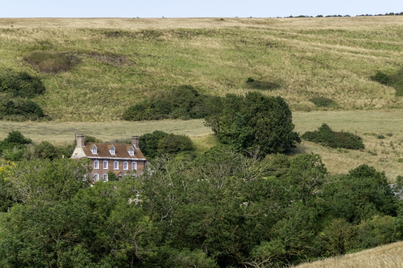
South Down Farmhouse
and attached front
26.1.56 walls
- II
Detached farmhouse. Early C18. Brick walls in English bond (front
elevation), rubblestone remaining walls. Clay tile roofs with stone
slate eaves. Brick stacks at gable ends with moulded cornices. 2 storeys
and dormers. 5 windows, symmetrical fenestration, sashes with glazing-
bars, with segmental heads and flush wood frames. Stone cills, brick
arches with burnt headers and keystones. 3 gabled dormers, with 2
light casements, tile roofs, C20. Additions on both gable ends, rubblestone
and brick with pentice clay tile roofs. Plank door on right end.
Front door at centre, plank door in a wood frame, C19. Brick porch with
segmental head, keystone and gabled, tiled roof. Short rear wing,
rubblestone and brick quoins, with brick stack at gable end, added C19.
Interior: central transverse hall, with a room either side. Ribbed
panel window shutters, C19. Attached rubblestone front walls, run for
20 metres by 20 metres. (R.C.H.M. Dorset II, p. 188 (15)).
Listing NGR: SY7572982196
External links are from the relevant listing authority and, where applicable, Wikidata. Wikidata IDs may be related buildings as well as this specific building. If you want to add or update a link, you will need to do so by editing the Wikidata entry.


Other nearby listed buildings
