Approximate Location Map
Large Map »
Latitude: 52.6906 / 52°41'26"N
Longitude: -0.6313 / 0°37'52"W
OS Eastings: 492608
OS Northings: 311201
OS Grid: SK926112
Mapcode National: GBR DSV.976
Mapcode Global: WHGLN.8MNP
Plus Code: 9C4XM9R9+6F
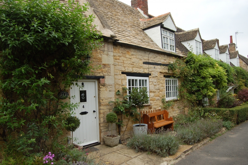
Entry Name: 4, Blacksmiths Lane
Listing Date: 18 September 1984
Grade: II
Source: Historic England
Source ID: 1307333
English Heritage Legacy ID: 187325
ID on this website: 101307333
Location: Exton, Rutland, LE15
County: Rutland
Civil Parish: Exton and Horn
Built-Up Area: Exton
Traditional County: Rutland
Lieutenancy Area (Ceremonial County): Rutland
Church of England Parish: Exton with Horn St Peter and St Paul
Church of England Diocese: Peterborough
Tagged with: Building
SK 9211 - 9311 EXTON BLACKSMITHS LANE (north side)
5/42 No. 4
GV II
Terraced cottage, late C17 or early C18. Coursed sandstone rubble with
angle quoins. 1½ storeys, 2 units with door to left, ground floor
windows have moulded stone architraves and hoodmoulds. Dormers have
timbering and decorated bargeboards (C19 or C20). Coped gable and gable
end stacks wing to rear.
Listing NGR: SK9260811201
External links are from the relevant listing authority and, where applicable, Wikidata. Wikidata IDs may be related buildings as well as this specific building. If you want to add or update a link, you will need to do so by editing the Wikidata entry.


Other nearby listed buildings
