Approximate Location Map
Large Map »
Latitude: 50.222 / 50°13'19"N
Longitude: -5.2327 / 5°13'57"W
OS Eastings: 169502
OS Northings: 40781
OS Grid: SW695407
Mapcode National: GBR Z3.F2K5
Mapcode Global: VH12K.8P15
Plus Code: 9C2P6QC8+RW
Entry Name: Pump Engine House on Site of Wheal Uny Mine at SW 695 408
Listing Date: 12 September 1989
Grade: II
Source: Historic England
Source ID: 1309729
English Heritage Legacy ID: 66889
ID on this website: 101309729
Location: Church Town, Cornwall, TR16
County: Cornwall
Civil Parish: Redruth
Traditional County: Cornwall
Lieutenancy Area (Ceremonial County): Cornwall
Church of England Parish: Redruth
Church of England Diocese: Truro
Tagged with: Pump
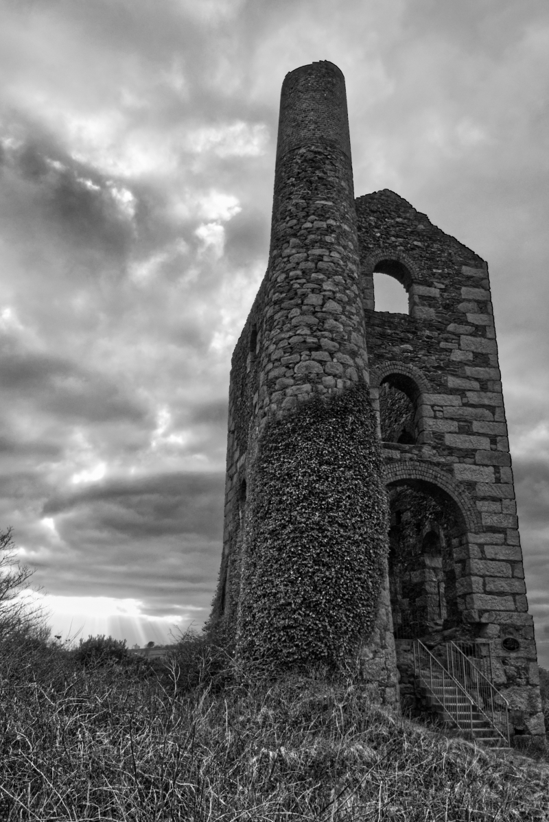
REDRUTH WHEAL UNY
SW 64 SE
5/324 Pump engine house on site of
Wheal Uny Mine at SW 695 408
GV II
Pump engine house to former tin mine, now derelict. Probably later C19. Dressed
granite blocks and killas rubble, with bob wall of massive rectangular blocks,
window arches of brick, brick upper stage to chimney; now roofless. Rectangular
plan on east-west axis, with bob wall to west, chimney attached at south-east
corner. Large building of 3 stages set back over a plinth (exposed on north side
by falling ground), with round-headed openings including an unusual tall 2-stage
slot in the bob wall (extending from ground level), with the driver's window in
the upper part; and large cylinder door in rear wall. Tapered cylindrical chimney
with no cornice to the stone stage, top of brick stage missing. History: mine
worked from before 1800, employed over 400 in 1860's, produced tin from Great
Flat Lode and had had reached 244 fathoms by the time it closed in 1893
(reference D.B.Barton A Guide to the Mines of West Cornwall, 3rd edn., 1973,
p.34)
Forms part of very conspicuous and attractively sited group, within sight of
remains of Basset Mines at Carnkie, Carn Brea (q.v.).
Listing NGR: SW6950040800
External links are from the relevant listing authority and, where applicable, Wikidata. Wikidata IDs may be related buildings as well as this specific building. If you want to add or update a link, you will need to do so by editing the Wikidata entry.


Other nearby listed buildings
