Approximate Location Map
Large Map »
Latitude: 51.6234 / 51°37'24"N
Longitude: -0.7352 / 0°44'6"W
OS Eastings: 487654
OS Northings: 192378
OS Grid: SU876923
Mapcode National: GBR D5C.0ZL
Mapcode Global: VHDW5.6GPB
Plus Code: 9C3XJ7F7+9W
Entry Name: Bassetsbury Manor
Listing Date: 9 January 1954
Grade: II*
Source: Historic England
Source ID: 1310947
English Heritage Legacy ID: 45963
ID on this website: 101310947
Location: Buckinghamshire, HP11
County: Buckinghamshire
Electoral Ward/Division: Ryemead
Parish: Non Civil Parish
Built-Up Area: High Wycombe
Traditional County: Buckinghamshire
Lieutenancy Area (Ceremonial County): Buckinghamshire
Church of England Parish: High Wycombe Saint Andrew
Church of England Diocese: Oxford
Tagged with: Manor house
BASSETSBURY LANE
1.
963
Bassetsbury Manor
SU 8792 5/59 9.1.54.
II* GV
2.
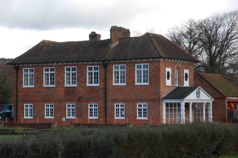
Late C17 or early C18. Red and chequered red and grey brickwork, old tiled.
roof. L-plan with main fronts north and west. North front has chamfered
plinth, 1st floor stringcourse, wooden modillioned cornice. 7 wood mullioned
and transomed 2 light flush casements under flat arches, 1st floor aprons.
Central 2 fold 12 fielded panel door in architrave frame, surround of slim
brick pilasters, ovolo cornice surmounted by lead cartouche. Rainwater
head dated 1734 with initials SW.
West front of similar design, 6 windows. South end, rebuilt circa 1930,
his wooden loggia with C17 Corinthian columns from a house in Nottingham
Market Place. Upper storey of south front redesigned with central round
headed window, in brick panel with rusticated flint surround, flanking
oblong panels containing carved wooden reliefs of animal masks above scroll-
work.
Chimney stack with 4 diagonally set shafts suggests C17 structure. Back
elevations partly C16 in character.
Chequers, Bassetsbury Mill, Manor, Stables and Barn form a group.
Listing NGR: SU8765492378
External links are from the relevant listing authority and, where applicable, Wikidata. Wikidata IDs may be related buildings as well as this specific building. If you want to add or update a link, you will need to do so by editing the Wikidata entry.


Other nearby listed buildings
