Approximate Location Map
Large Map »
Latitude: 54.5366 / 54°32'11"N
Longitude: -1.0498 / 1°2'59"W
OS Eastings: 461580
OS Northings: 516118
OS Grid: NZ615161
Mapcode National: GBR PH3Z.JJ
Mapcode Global: WHF8D.V78H
Plus Code: 9C6WGXP2+J3
Entry Name: 53, Church Street
Listing Date: 25 April 1984
Grade: II
Source: Historic England
Source ID: 1310992
English Heritage Legacy ID: 59939
ID on this website: 101310992
Location: Guisborough, Redcar and Cleveland, North Yorkshire, TS14
County: Redcar and Cleveland
Civil Parish: Guisborough
Built-Up Area: Guisborough
Traditional County: Yorkshire
Lieutenancy Area (Ceremonial County): North Yorkshire
Church of England Parish: Guisborough St Nicholas
Church of England Diocese: York
Tagged with: Building
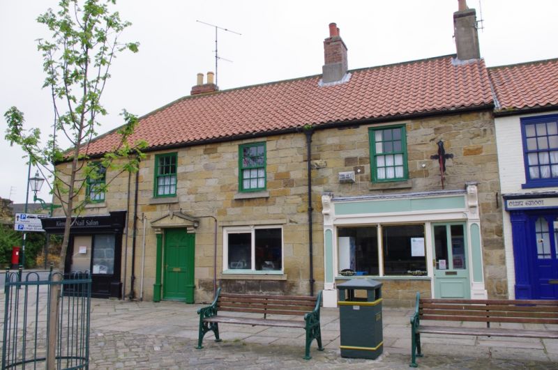
NZ6116 GUISBOROUCH CHURCH STREET
(NORTH SIDE)
7/71 No. 53.
II
House and shop. Late C18. Painted dressed sandstone; clay
pantile roof; stone ridge copings; brick stack to R.H.S. 2
storeys. Mid C20 ground floor shop front. Late C20 casement
window to first floor in original opening.
Listing NGR: NZ6158016119
External links are from the relevant listing authority and, where applicable, Wikidata. Wikidata IDs may be related buildings as well as this specific building. If you want to add or update a link, you will need to do so by editing the Wikidata entry.


Other nearby listed buildings
