Approximate Location Map
Large Map »
Latitude: 51.9299 / 51°55'47"N
Longitude: -0.562 / 0°33'43"W
OS Eastings: 498972
OS Northings: 226687
OS Grid: SP989266
Mapcode National: GBR F31.W7J
Mapcode Global: VHFR5.6RRD
Plus Code: 9C3XWCHQ+X6
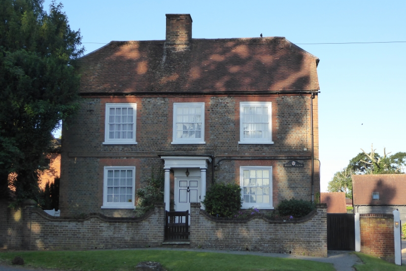
Entry Name: Park Farmhouse
Listing Date: 26 September 1980
Grade: II
Source: Historic England
Source ID: 1311567
English Heritage Legacy ID: 35906
ID on this website: 101311567
Location: Tebworth, Central Bedfordshire, LU7
County: Central Bedfordshire
Civil Parish: Chalgrave
Built-Up Area: Tebworth
Traditional County: Bedfordshire
Lieutenancy Area (Ceremonial County): Bedfordshire
Church of England Parish: Chalgrave
Church of England Diocese: St.Albans
Tagged with: Farmhouse
1.
5125 CHALGRAVE HOCKLIFFE ROAD
(south side)
Tebworth
Park Farmhouse
SF 9826 14/54
SF 9926 15/54
II GV
2.
C18. Grey brick with red brick dressings. Half-hipped old clay tile roof. Trio
storeys. Modillion cornice. Three flush sash windows with glazing bars. First
floor band. Doric porch.
Listing NGR: SP9897226687
External links are from the relevant listing authority and, where applicable, Wikidata. Wikidata IDs may be related buildings as well as this specific building. If you want to add or update a link, you will need to do so by editing the Wikidata entry.


Other nearby listed buildings
