Approximate Location Map
Large Map »
Latitude: 53.7911 / 53°47'27"N
Longitude: -2.2517 / 2°15'6"W
OS Eastings: 383516
OS Northings: 432780
OS Grid: SD835327
Mapcode National: GBR DSQL.9R
Mapcode Global: WHB7X.DZ02
Plus Code: 9C5VQPRX+C8
Entry Name: Burnley House
Listing Date: 29 September 1977
Grade: II
Source: Historic England
Source ID: 1313390
English Heritage Legacy ID: 467240
ID on this website: 101313390
Location: Stoneyholme, Burnley, Lancashire, BB11
County: Lancashire
District: Burnley
Electoral Ward/Division: Trinity
Parish: Non Civil Parish
Built-Up Area: Burnley
Traditional County: Lancashire
Lieutenancy Area (Ceremonial County): Lancashire
Church of England Parish: Burnley (Habergham Eaves) St Matthew the Apostle
Church of England Diocese: Blackburn
Tagged with: House
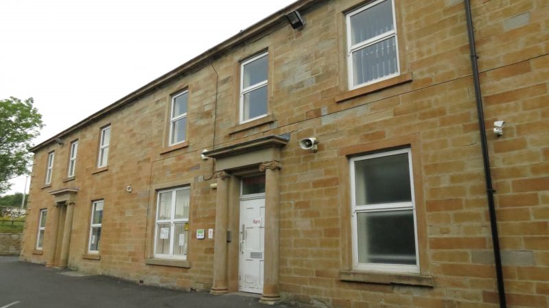
BURNLEY
SD8332NE WESTGATE
906-1/15/153 (North side)
29/09/77 Nos.39, 41 AND 43
Burnley House
GV II
Terrace of 3 town houses, now integrated as residential
nursing home. Early to mid C19; altered. Sandstone ashlar,
slate roof hipped at right-hand end. Double-depth plan, each
house double-fronted, plus a set-back receding wing at the
right-hand end.
2 storeys over cellars, 3+3+3 windows, formerly symmetrical;
with raised rusticated quoins and a moulded gutter cornice.
Each house has a symmetrical facade with a large central
doorway which has an Ionic architrave with engaged columns,
plain frieze and moulded cornice, and a recessed panelled door
with plain overlight (No.43 to the left now lacking the
cornice); No.41 now has an enlarged window to the left at
ground floor, otherwise, all the windows are
vertical-rectangular with raised sills and plain surrounds,
and all now with altered glazing. Coped gable and gable
chimney to No.43, ridge chimney at junction of Nos 41 & 43
(both these chimneys corniced), and 2 other ridge chimneys cut
down. Left gable wall of watershot masonry, with 4 windows at
ground floor and one above, and an unusual horizontal gutter
at carried on a corbel-table at eaves level (presumably to
convey rainwater from the front gutter to a downspout at the
rear). Receding wing at the right-hand end, single-storey, in
similar style to front. C20 extensions to the rear.
INTERIORS not inspected.
Listing NGR: SD8351632780
External links are from the relevant listing authority and, where applicable, Wikidata. Wikidata IDs may be related buildings as well as this specific building. If you want to add or update a link, you will need to do so by editing the Wikidata entry.


Other nearby listed buildings
