Approximate Location Map
Large Map »
Latitude: 53.5746 / 53°34'28"N
Longitude: -1.7509 / 1°45'3"W
OS Eastings: 416591
OS Northings: 408692
OS Grid: SE165086
Mapcode National: GBR JW63.QB
Mapcode Global: WHCBG.2FH0
Plus Code: 9C5WH6FX+RJ
Entry Name: Gate Piers and Gates to Christ Church
Listing Date: 4 August 1983
Grade: II
Source: Historic England
Source ID: 1313602
English Heritage Legacy ID: 340536
ID on this website: 101313602
Location: Christ Church, New Mill, Kirklees, West Yorkshire, HD9
County: Kirklees
Civil Parish: Holme Valley
Built-Up Area: Holmfirth
Traditional County: Yorkshire
Lieutenancy Area (Ceremonial County): West Yorkshire
Church of England Parish: New Mill Christ Church
Church of England Diocese: Leeds
Tagged with: Gatepost
SE 10 NE SUDE HILL
5/309 (New Mill)
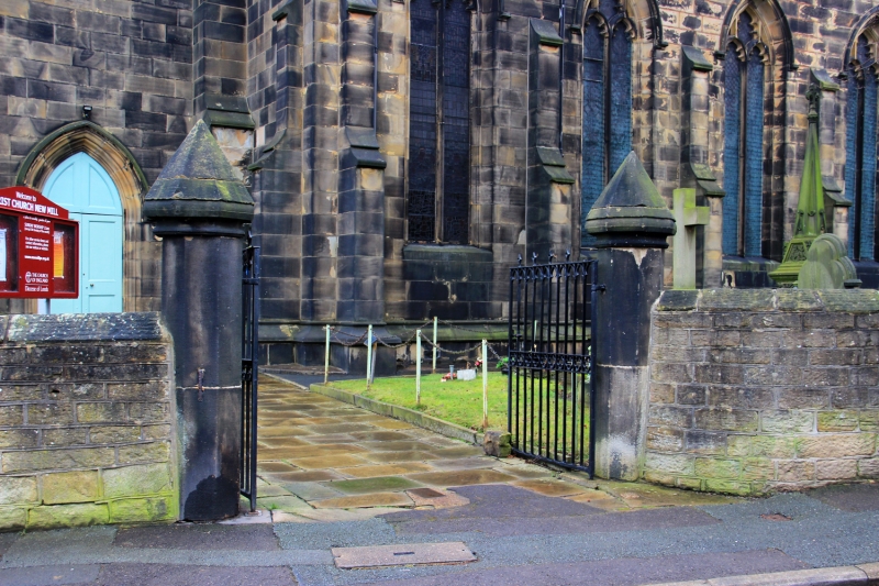
Gate Piers and Gates
to Christ Church
GV
II
Circa 1830. Octagonal stone gate piers with iron gates.
Listing NGR: SE1659108692
External links are from the relevant listing authority and, where applicable, Wikidata. Wikidata IDs may be related buildings as well as this specific building. If you want to add or update a link, you will need to do so by editing the Wikidata entry.


Other nearby listed buildings
