Approximate Location Map
Large Map »
Latitude: 53.6902 / 53°41'24"N
Longitude: -1.7414 / 1°44'29"W
OS Eastings: 417173
OS Northings: 421564
OS Grid: SE171215
Mapcode National: GBR JT8R.SW
Mapcode Global: WHC9W.7H0V
Plus Code: 9C5WM7R5+3C
Entry Name: Calder and Hebble Navigation Kirklees Low Lock Kirklees Cut Kirklees Low Lock
Listing Date: 29 September 1978
Grade: II
Source: Historic England
Source ID: 1313800
English Heritage Legacy ID: 339637
ID on this website: 101313800
Location: Kirklees, West Yorkshire, HD6
County: Kirklees
Electoral Ward/Division: Ashbrow
Parish: Non Civil Parish
Traditional County: Yorkshire
Lieutenancy Area (Ceremonial County): West Yorkshire
Church of England Parish: Bradley St Thomas
Church of England Diocese: Leeds
Tagged with: Lock
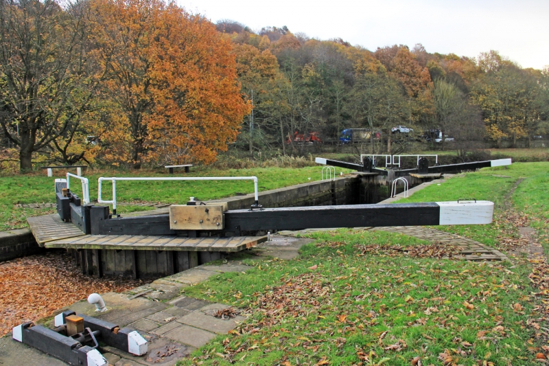
CALDER AND HEBBLE NAVIGATION
1.
5113
KIRKLEES CUT
Kirklees Low Lock
SE 1721 8/290
II
2.
C18. Stone retaining walls. Stone and wooden bollards. Mooring irons. 2
pairs of lock gates.
Listing NGR: SE1717321564
External links are from the relevant listing authority and, where applicable, Wikidata. Wikidata IDs may be related buildings as well as this specific building. If you want to add or update a link, you will need to do so by editing the Wikidata entry.


Other nearby listed buildings
