Approximate Location Map
Large Map »
Latitude: 53.4538 / 53°27'13"N
Longitude: -1.3715 / 1°22'17"W
OS Eastings: 441836
OS Northings: 395410
OS Grid: SK418954
Mapcode National: GBR LXVH.WM
Mapcode Global: WHDDB.XG33
Plus Code: 9C5WFJ3H+GC
Entry Name: 33-39, Coach Road
Listing Date: 13 May 1969
Last Amended: 19 February 1986
Grade: II
Source: Historic England
Source ID: 1314597
English Heritage Legacy ID: 335665
ID on this website: 101314597
Location: Greasbrough, Rotherham, South Yorkshire, S61
County: Rotherham
Electoral Ward/Division: Wingfield
Parish: Non Civil Parish
Built-Up Area: Rotherham
Traditional County: Yorkshire
Lieutenancy Area (Ceremonial County): South Yorkshire
Church of England Parish: Greasbrough St Mary
Church of England Diocese: Sheffield
Tagged with: Building
SK49NW ROTHERHAM COACH ROAD
(south side),
Greasbrough
2/33 Nos 33-39 (odd)
(formerly listed
as Chapel Houses
13.5.69 No 1, No 2, No 3,
No 4)
- II
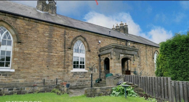
Houses. c1828. Coursed, dressed sandstone, Welsh slate roof with original stone
slates retained on part of rear roof. Symmetrical single-storey facade with 4
windows, 2 doors within central porch, gable entries to end houses. Plinth.
C20 doors within central, flat-roofed, ashlar porch with front and sides pierced
by Tudor-arched openings with hood-moulds; roll-moulded parapet copings. Flanking
windows have flush sills and quoined reveals to pointed arches with hoodmoulds, all
have casements with intersecting glazing bars. Chamfered band at eaves, moulded
gable copings. 2 groups of ridge stacks, each with 6 diagonally-set, square,
shafts on linked plinths. Rear: extensively altered. Left return: central door
in chamfered, quoined opening with hoodmould. Flanking pointed-arched openings
as front, that to left blind, that to right now with casement. Inserted casement
over door, eaves band continuous across gable. Right return: similar but with
reused limestone surround to blind gable oculus. Formerly called Chapel Houses
having been constructed out of stone from the Chapel of Holy Trinity demolished
in 1827 to make way for St. Mary's Church (q.v.).
Listing NGR: SK4183695410
External links are from the relevant listing authority and, where applicable, Wikidata. Wikidata IDs may be related buildings as well as this specific building. If you want to add or update a link, you will need to do so by editing the Wikidata entry.


Other nearby listed buildings
