Approximate Location Map
Large Map »
Latitude: 50.5005 / 50°30'1"N
Longitude: -3.5858 / 3°35'8"W
OS Eastings: 287632
OS Northings: 67945
OS Grid: SX876679
Mapcode National: GBR QS.FVT6
Mapcode Global: FRA 37CQ.YPB
Plus Code: 9C2RGC27+5M
Entry Name: Dobbin Arch
Listing Date: 17 July 1987
Grade: II
Source: Historic England
Source ID: 1317532
English Heritage Legacy ID: 84894
ID on this website: 101317532
Location: Kingskerswell, Teignbridge, Devon, TQ12
County: Devon
District: Teignbridge
Civil Parish: Kingskerswell
Built-Up Area: Kingskerswell
Traditional County: Devon
Lieutenancy Area (Ceremonial County): Devon
Church of England Parish: Kingskerswell St Mary
Church of England Diocese: Exeter
Tagged with: Architectural structure
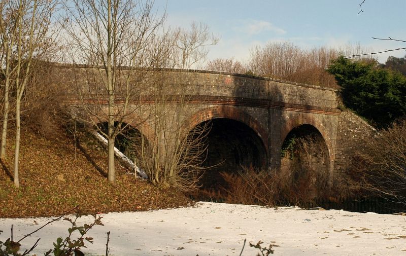
SX 86 NE KINGSKERSWELL SCHOOL ROAD, Kingskerswell
3/183 Dobbin Arch
-
- II
Road bridge over railway line. 1846-48. Engineer I K Brunel. Limestone blocks
with dressed coping stones and brick arches.
3-span elliptical arches with slightly projecting pilasters between arches and
moulded stringcourse above.
In 1846 South Devon Railway obtained permission to construct a branch line from
newton Abbot to Torquay passing through Kingskerswell. It was opened in December
1848.
Sources! Devon Sites and Monuments Register.
Railways of the Western Region - Geoffrey Body.
Listing NGR: SX8763267945
External links are from the relevant listing authority and, where applicable, Wikidata. Wikidata IDs may be related buildings as well as this specific building. If you want to add or update a link, you will need to do so by editing the Wikidata entry.


Other nearby listed buildings
