Approximate Location Map
Large Map »
Latitude: 53.4757 / 53°28'32"N
Longitude: -2.1495 / 2°8'58"W
OS Eastings: 390176
OS Northings: 397668
OS Grid: SJ901976
Mapcode National: GBR FXF7.FS
Mapcode Global: WHB9H.YWMW
Plus Code: 9C5VFVG2+76
Entry Name: 19, Fairfield Square
Listing Date: 17 November 1966
Last Amended: 14 July 1987
Grade: II
Source: Historic England
Source ID: 1318078
English Heritage Legacy ID: 212729
ID on this website: 101318078
Location: Droylsden, Tameside, Greater Manchester, M43
County: Tameside
Electoral Ward/Division: Droylsden East
Parish: Non Civil Parish
Built-Up Area: Droylsden
Traditional County: Lancashire
Lieutenancy Area (Ceremonial County): Greater Manchester
Church of England Parish: Droylsden St Mary
Church of England Diocese: Manchester
Tagged with: Building
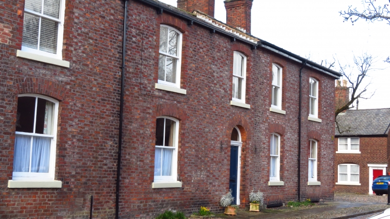
DROYLSDEN FAIRFIELD SQUARE
SJ 99 NW
4/73 No. 19
(formerly listed
as Nos 19A and 19B)
17/11/66
G.V. II
House. C19. Header bond brick with slate roof. 5 bays and 2
storeys. Symmetrical elevation. Central 4-panel door with
fanlight. 4 ground floor and 5 first floor windows with 4-
pane sashes, stone sills and segmental-arched heads. 2
similar windows to right return. Ridge chimney stacks.
Included for group value and as an integral part of the
Moravian Settlement.
Listing NGR: SJ9017697668
External links are from the relevant listing authority and, where applicable, Wikidata. Wikidata IDs may be related buildings as well as this specific building. If you want to add or update a link, you will need to do so by editing the Wikidata entry.


Other nearby listed buildings
