Approximate Location Map
Large Map »
Latitude: 54.4676 / 54°28'3"N
Longitude: -1.545 / 1°32'42"W
OS Eastings: 429586
OS Northings: 508117
OS Grid: NZ295081
Mapcode National: GBR KJNS.98
Mapcode Global: WHC63.7YJZ
Plus Code: 9C6WFF93+2X
Entry Name: Town End Farmhouse
Listing Date: 17 September 1987
Grade: II
Source: Historic England
Source ID: 1318350
English Heritage Legacy ID: 322685
ID on this website: 101318350
Location: Dalton-on-Tees, North Yorkshire, DL2
County: North Yorkshire
District: Richmondshire
Civil Parish: Dalton-on-Tees
Traditional County: Yorkshire
Lieutenancy Area (Ceremonial County): North Yorkshire
Church of England Parish: Croft
Church of England Diocese: Leeds
Tagged with: Farmhouse
DALTON-ON-TEES DALTON-ON-TEES
NZ 20 NE
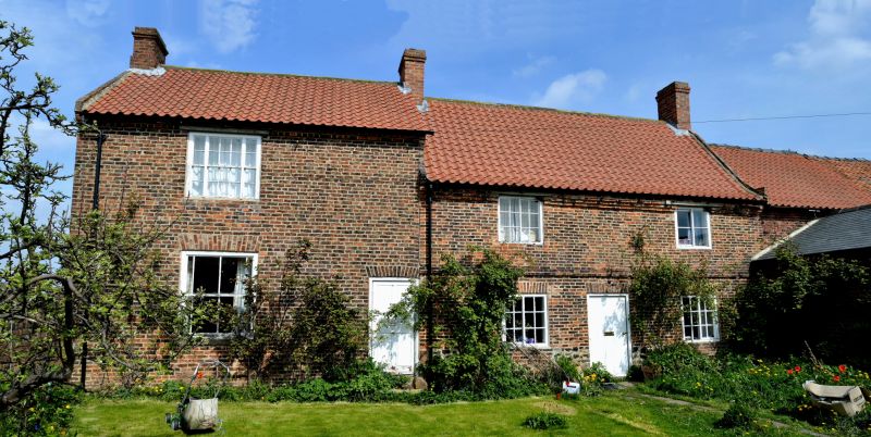
8/46 Town End Farmhouse
17/9/87 II
2 houses, now 1. Early C18 and mid C19. Red brick in Flemish bond, pantile
roofs. 2 storeys, 1:2 first-floor windows. Older range to right: central
board door, flanking it on each floor a side-sliding sash window with flat
arch. Stepped string courses and stepped eaves courses, the latter
interrupted by the first-floor windows. Raised verge to right. End stacks.
Later range taller: to right, board door, and on each floor a tripartite
sash window. Eaves band. Raised verge and end stack to left.
Listing NGR: NZ2958608117
External links are from the relevant listing authority and, where applicable, Wikidata. Wikidata IDs may be related buildings as well as this specific building. If you want to add or update a link, you will need to do so by editing the Wikidata entry.


Other nearby listed buildings
