Approximate Location Map
Large Map »
Latitude: 51.45 / 51°27'0"N
Longitude: -0.8574 / 0°51'26"W
OS Eastings: 479497
OS Northings: 172955
OS Grid: SU794729
Mapcode National: GBR C60.02D
Mapcode Global: VHDWW.3T39
Plus Code: 9C3XF42V+23
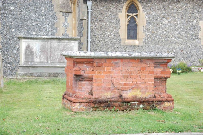
Entry Name: Tomb in St Nicholas Churchyard 12 Metres South of Church
Listing Date: 17 October 1983
Grade: II
Source: Historic England
Source ID: 1319472
English Heritage Legacy ID: 41222
ID on this website: 101319472
Location: St Nicholas's Church, Hurst, Wokingham, Berkshire, RG10
County: Wokingham
Civil Parish: St. Nicholas, Hurst
Traditional County: Berkshire
Lieutenancy Area (Ceremonial County): Berkshire
Church of England Parish: Hurst
Church of England Diocese: Oxford
Tagged with: Tomb
SU 77SE ST NICHOLAS HURST CHURCH HILL
(north side)
5/30 Tomb In St.Nicholas
Churchyard 12 Metres
South Of Church
GV II
Tomb. Early C18, moulded and carved brick base, stone capping eroded.
Listing NGR: SU7949772955
External links are from the relevant listing authority and, where applicable, Wikidata. Wikidata IDs may be related buildings as well as this specific building. If you want to add or update a link, you will need to do so by editing the Wikidata entry.


Other nearby listed buildings
