Approximate Location Map
Large Map »
Latitude: 51.3814 / 51°22'52"N
Longitude: -1.1683 / 1°10'5"W
OS Eastings: 457979
OS Northings: 165032
OS Grid: SU579650
Mapcode National: GBR 93P.CFY
Mapcode Global: VHCZM.PJRW
Plus Code: 9C3W9RJJ+HM
Entry Name: Granary Adjoining Nos 60 and 61 Lower Farmhouse to South
Listing Date: 10 November 1983
Grade: II
Source: Historic England
Source ID: 1319548
English Heritage Legacy ID: 39659
ID on this website: 101319548
Location: Wasing, West Berkshire, RG7
County: West Berkshire
Civil Parish: Wasing
Traditional County: Berkshire
Lieutenancy Area (Ceremonial County): Berkshire
Church of England Parish: Aldermaston
Church of England Diocese: Oxford
Tagged with: Granary
WASING WASING LANE (north side)
SU 56NE
3/59 Granary Adjoining Nos. 60
And 61 Lower Farmhouse To
South
GV II
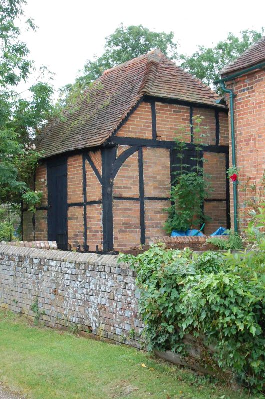
Granary. C17. Timber framed with brick nogging and old tile half hipped roof. Square
plan on 9 staddlestones. Arch bracing on all sides with window and blocked door
to south; boarded door to east.
Listing NGR: SU5797965032
External links are from the relevant listing authority and, where applicable, Wikidata. Wikidata IDs may be related buildings as well as this specific building. If you want to add or update a link, you will need to do so by editing the Wikidata entry.


Other nearby listed buildings
