Approximate Location Map
Large Map »
Latitude: 52.6308 / 52°37'51"N
Longitude: -0.5654 / 0°33'55"W
OS Eastings: 497195
OS Northings: 304642
OS Grid: SK971046
Mapcode National: GBR DTQ.1WP
Mapcode Global: WHGM2.941G
Plus Code: 9C4XJCJM+8V
Entry Name: Windmill
Listing Date: 17 December 1984
Grade: II
Source: Historic England
Source ID: 1320092
English Heritage Legacy ID: 187142
ID on this website: 101320092
Location: Ketton, Rutland, PE9
County: Rutland
Civil Parish: Ketton
Built-Up Area: Ketton
Traditional County: Rutland
Lieutenancy Area (Ceremonial County): Rutland
Church of England Parish: Ketton St Mary the Virgin
Church of England Diocese: Peterborough
Tagged with: Windmill
SK 9604-9704 KETTON EMPINGHAM ROAD
14/53 (west side)
Windmill
II
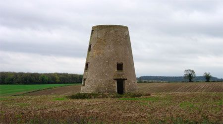
Tower mill, C18. Of squared stone, rendered. Tower of squat conical section,
4-storeys high, on plinth. Two door and 2 window openings to ground floor, window
openings to south, west and east at 1st floor level, and to south and north at 2nd
and 3rd floor levels,all beneath timber lintels. No internal floors or machinery
remain.
Listing NGR: SK9719504642
External links are from the relevant listing authority and, where applicable, Wikidata. Wikidata IDs may be related buildings as well as this specific building. If you want to add or update a link, you will need to do so by editing the Wikidata entry.


Other nearby listed buildings
