Approximate Location Map
Large Map »
Latitude: 51.5726 / 51°34'21"N
Longitude: -2.5657 / 2°33'56"W
OS Eastings: 360892
OS Northings: 186122
OS Grid: ST608861
Mapcode National: GBR JR.D5BP
Mapcode Global: VH882.GQZT
Plus Code: 9C3VHCFM+2P
Entry Name: Lower Farmhouse
Listing Date: 5 December 1984
Grade: II
Source: Historic England
Source ID: 1321053
English Heritage Legacy ID: 35312
ID on this website: 101321053
Location: Tockington, South Gloucestershire, BS32
County: South Gloucestershire
Civil Parish: Olveston
Built-Up Area: Tockington
Traditional County: Gloucestershire
Lieutenancy Area (Ceremonial County): Gloucestershire
Church of England Parish: Olveston
Church of England Diocese: Bristol
Tagged with: Farmhouse
ST 68 NW OLVESTON LOWER TOCKINGTON ROAD (east
side) Tockington
8/203
Lower Farmhouse
- II
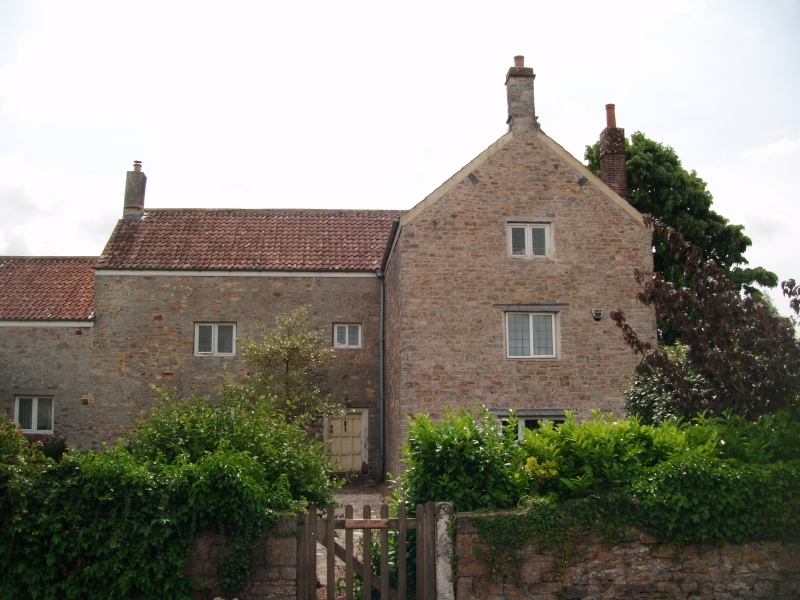
Farmhouse, now house. C17 with later alterations. Rubble, rendered, pantiled
roof with gable stacks. L-plan, former through passage, including lower wing
to north. 2½ storeys, 2:1 windows, all 2-light casements with moulded frames
and C20 leaded lights, small window at attic level west and north, 3rd bay from
left has door of 9 panels with heavy raised moulded battens and studs, latch and
knocker, bolection moulded and stopped frame with stone bases to-jambs. North
elevation has C20 upper window and small lean-to, south elevation has 2 windows
to ground floor as on front, and C20 dormer; rear has 2:2 windows as on front
and 2 dormers, single storey extension, 2 windows under eaves of lower wing and
C20 door to left. Interior: plank and batten doors, door to rear of through
passage similar to front, chamfered and scroll stopped beams, cambered lintel to
fireplace, winder to left of passage. Formerly called Gosling Farm.
Listing NGR: ST6089286122
External links are from the relevant listing authority and, where applicable, Wikidata. Wikidata IDs may be related buildings as well as this specific building. If you want to add or update a link, you will need to do so by editing the Wikidata entry.


Other nearby listed buildings
