Approximate Location Map
Large Map »
Latitude: 51.1279 / 51°7'40"N
Longitude: 0.4081 / 0°24'29"E
OS Eastings: 568601
OS Northings: 139271
OS Grid: TQ686392
Mapcode National: GBR NRH.804
Mapcode Global: VHJMY.1X37
Plus Code: 9F324CH5+56
Entry Name: Hale Farmhouse
Listing Date: 20 October 1954
Grade: II*
Source: Historic England
Source ID: 1322819
English Heritage Legacy ID: 169926
ID on this website: 101322819
Location: Hazel Street, Tunbridge Wells, Kent, TN12
County: Kent
District: Tunbridge Wells
Civil Parish: Horsmonden
Traditional County: Kent
Lieutenancy Area (Ceremonial County): Kent
Church of England Parish: Horsmonden St Margaret
Church of England Diocese: Rochester
Tagged with: Farmhouse
HORSMONDEN MARLE PLACE ROAD
TQ 63 NE
(south side)
3/90 Hale Farmhouse
20.10.54
GV II*
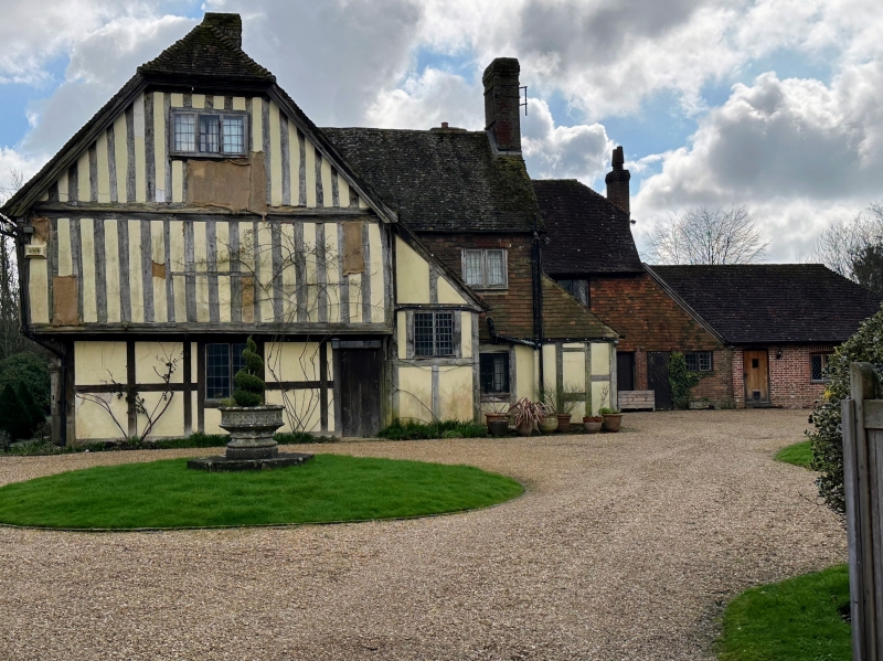
House. C15, altered and extended mid-late C16, C18 and C20. Timber framed and
exposed with plaster infill on sandstone base, with tile hung rear and return
elevations with some red brick. Plain tiled roofs. Probable hall house in origin
extended by lobby entry plan continuous jettied range. Two storeys on plinth with
moulded bresumner to jetty on moulded brackets and returned on dragon post, with
small panel frame on ground floor and close studding on first floor. Roof hipped to
left and half-hipped to right with stacks to centre right and clustered to centre
left and with central hipped dormer. C20 fenestration of 7 irregularly spaced leaded
cross windows on first floor and 3 large 3 light mullioned and transomed windows
on ground floor. C16 wave moulded rib and stud door to centre left with rectangular
fanlight. Right return with jetty and moulded bargeboarded half-hipped gable on
doubled wall plate. Left return wing tile hung, in character a lobby entry plan, 2
storeys with cluster to centre left (and blocked doorway under the tiles at this
point) and C20 rebuilt stack at end left in outshot; four wooden casements on first
floor and 3 mullioned and transomed windows on ground floor. C18 and late C20
extensions to rear, forming a small courtyard. Interior: Right return wing may
represent the earliest phase, at present with C16 clasped purlin roof with
diminished principals, but re-using smoke blackened rafters (not a smoke bay as
otherwise reported), although this may be a later phase to the front range since the
joining bay of this wing and the main range mixes certain framing and roofing
elements confusing the order of precedence of the two wings. Main range with
clasped purlin roof, taller than side wing, and extensively moulded beams
throughout, the parlour (to left at the junction of the 2 wings) with C17 bolection
moulded panelling with dado and frieze, brought in from elsewhere and cut to fit the
room and with some early C20 sections made to order. Stop chamfered crossed beams
in upper ceilings. Stack with inglenooks, bread oven and round backed minor
fireplaces. Turned baluster single flight stair.
Listing NGR: TQ6855139521
External links are from the relevant listing authority and, where applicable, Wikidata. Wikidata IDs may be related buildings as well as this specific building. If you want to add or update a link, you will need to do so by editing the Wikidata entry.


Other nearby listed buildings
