Approximate Location Map
Large Map »
Latitude: 54.5549 / 54°33'17"N
Longitude: -1.3382 / 1°20'17"W
OS Eastings: 442900
OS Northings: 517940
OS Grid: NZ429179
Mapcode National: GBR MH3R.2Z
Mapcode Global: WHD6Y.FS00
Plus Code: 9C6WHM36+XP
Entry Name: The Manor House
Listing Date: 19 January 1951
Last Amended: 21 June 1985
Grade: II*
Source: Historic England
Source ID: 1325975
English Heritage Legacy ID: 59275
ID on this website: 101325975
Location: Hartburn, Stockton-on-Tees, North Yorkshire, TS18
County: Stockton-on-Tees
Electoral Ward/Division: Hartburn
Parish: Non Civil Parish
Built-Up Area: Stockton-on-Tees
Traditional County: Durham
Lieutenancy Area (Ceremonial County): County Durham
Church of England Parish: Stockton-on-Tees St Peter
Church of England Diocese: Durham
Tagged with: House
NZ 4217 NE EAST HARTBURN HARTBURN VILLAGE
(North side)
32/177
Nos 14 and 16
19.1.51 (The Manor House)
(formerly listed as
No 15)
GV II
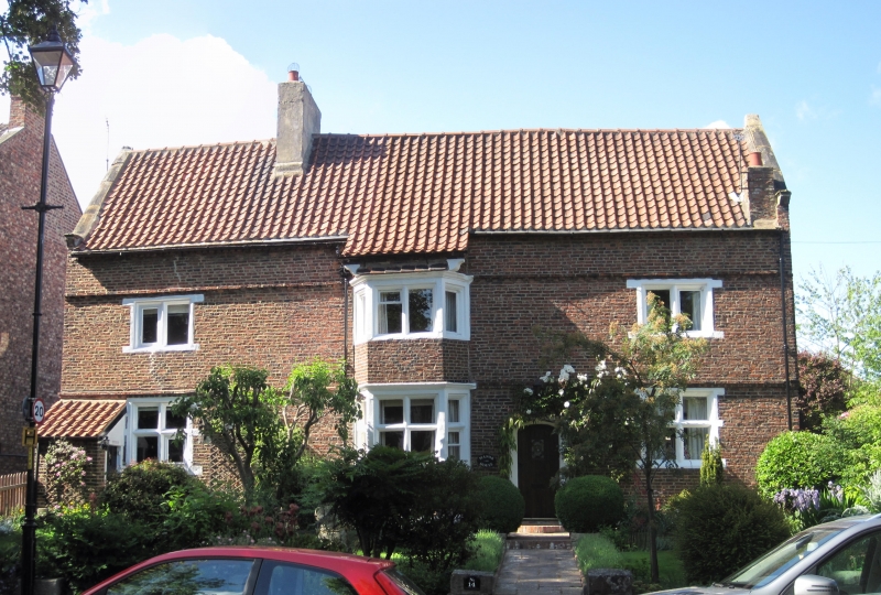
C17. The only completely vernacular house in Stockton. 2 storeys and attic.
Symmetrical front with 3 windows, the central one being a 2 storey canted bay of
4 lights per floor. Brick built with over-capped brick string course over ground
floor, modillion brick string course over 1st floor and raw-tooth eaves cornice.
Pantile roof with raised verges and kneelers. One large ridge rendered chimney
off centre to left. Central bay has kneelers at top and is roofed by an exten-
sion of the main roof slope at the same pitch and by bricks corbelled out at top
corners. Mullion windows 1st floor, mullion and transom windows on ground floor
with stone dressings, moulded architraves to lintels of windows in canted bay. 4
centred arch headed door to right of centre. Small pantiled lean-to at left.
Gable lit attic with stone mullion windows which have brick labels. One pointed
window at rear. Various lower pantiled extensions at rear. Large inglenook
fireplace in ground floor bay window room. The modern low crenellated front
garden wall to the street contains stones taken from the Packhorse Bridge, on
Portrack Lane. Demolished c.1965.
Listing NGR: NZ4290017940
External links are from the relevant listing authority and, where applicable, Wikidata. Wikidata IDs may be related buildings as well as this specific building. If you want to add or update a link, you will need to do so by editing the Wikidata entry.


Other nearby listed buildings
