Approximate Location Map
Large Map »
Latitude: 54.5258 / 54°31'32"N
Longitude: -2.675 / 2°40'30"W
OS Eastings: 356408
OS Northings: 514712
OS Grid: NY564147
Mapcode National: GBR 9JR3.ND
Mapcode Global: WH81Y.WHCS
Plus Code: 9C6VG8GF+8X
Entry Name: Croft House
Listing Date: 24 June 1987
Grade: II
Source: Historic England
Source ID: 1326751
English Heritage Legacy ID: 74175
ID on this website: 101326751
Location: Shap, Westmorland and Furness, Cumbria, CA10
County: Cumbria
District: Eden
Civil Parish: Shap
Built-Up Area: Shap
Traditional County: Westmorland
Lieutenancy Area (Ceremonial County): Cumbria
Church of England Parish: Shap with Swindale St Michael
Church of England Diocese: Carlisle
Tagged with: House
SHAP MAIN STREET
NY 5614/5 (West side) Shap
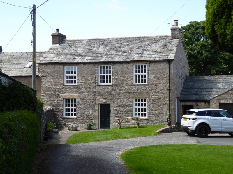
27/160 Croft House
GV II
House. Probably late C18. Coursed rubble with quoins. Graduated slate roof;
stone ridge. Symmetrical; 2 storeys, 3 bays. Central part-glazed door with
16-pane sash to either.side and 3 above; stone surrounds to all openings. Stone
end chimneys. C20 corrugated-iron garage adjoining north end not of interest.
Listing NGR: NY5640814711
External links are from the relevant listing authority and, where applicable, Wikidata. Wikidata IDs may be related buildings as well as this specific building. If you want to add or update a link, you will need to do so by editing the Wikidata entry.


Other nearby listed buildings
