Approximate Location Map
Large Map »
Latitude: 50.1149 / 50°6'53"N
Longitude: -5.5482 / 5°32'53"W
OS Eastings: 146434
OS Northings: 29899
OS Grid: SW464298
Mapcode National: GBR DXPC.TMS
Mapcode Global: VH05H.SC7R
Plus Code: 9C2P4F72+XP
Entry Name: Love Lane Farmhouse
Listing Date: 29 July 1950
Grade: II
Source: Historic England
Source ID: 1327458
English Heritage Legacy ID: 69503
ID on this website: 101327458
Location: Alverton, Cornwall, TR18
County: Cornwall
Civil Parish: Penzance
Built-Up Area: Penzance
Traditional County: Cornwall
Lieutenancy Area (Ceremonial County): Cornwall
Church of England Parish: Madron
Church of England Diocese: Truro
Tagged with: Farmhouse
1.
1498 PENZANCE
LOVE LANE
--------
Love Lane Farmhouse
SW 4629 7/48 29.7.50.
II
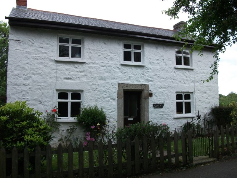
2.
Cottage said to be Cl7 although much altered from original, appears to have
been somewhat rebuilt in C19. Colour-washed, plastered rubble. Slate roof.
2 storeys. 3 windows, wood casements with elliptical headed fanlights over.
Doorway, granite lintel and jambs stop chamfered, carved on the lintel GDE1675.
Listing NGR: SW4643429899
External links are from the relevant listing authority and, where applicable, Wikidata. Wikidata IDs may be related buildings as well as this specific building. If you want to add or update a link, you will need to do so by editing the Wikidata entry.


Other nearby listed buildings
