Approximate Location Map
Large Map »
Latitude: 50.2075 / 50°12'27"N
Longitude: -5.4978 / 5°29'51"W
OS Eastings: 150523
OS Northings: 40025
OS Grid: SW505400
Mapcode National: GBR DXT4.6HV
Mapcode Global: VH12L.N1FQ
Plus Code: 9C2P6G52+2V
Entry Name: DR Stack's House
Listing Date: 22 December 1972
Grade: II
Source: Historic England
Source ID: 1327786
English Heritage Legacy ID: 69015
ID on this website: 101327786
Location: Cornwall, TR26
County: Cornwall
Civil Parish: St. Ives
Built-Up Area: St Ives
Traditional County: Cornwall
Lieutenancy Area (Ceremonial County): Cornwall
Church of England Parish: Halsetown
Church of England Diocese: Truro
Tagged with: House
HELLESVEAN ROAD
1. HELLESVEAN
1587 ---------------
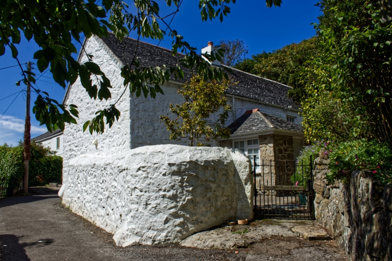
Dr Stack's House
SW 54 SW 3/201
II GV
2.
Late C18/early C19. Long house of painted rubble, partly faced. in vertical
slates above ground floor. Two storeys. Four windows overall, sashes
with glazing bars. Slurried slate roof with gable ends.
Dr Stack's House Corner Cottage Penrose Cottage, Rosedale and Treesdale
form a group.
Listing NGR: SW5052340025
External links are from the relevant listing authority and, where applicable, Wikidata. Wikidata IDs may be related buildings as well as this specific building. If you want to add or update a link, you will need to do so by editing the Wikidata entry.


Other nearby listed buildings
