Approximate Location Map
Large Map »
Latitude: 50.2153 / 50°12'55"N
Longitude: -5.2414 / 5°14'29"W
OS Eastings: 168847
OS Northings: 40059
OS Grid: SW688400
Mapcode National: GBR Z3.FD8L
Mapcode Global: VH12K.3VFB
Plus Code: 9C2P6Q85+4C
Entry Name: Chimney at SW 688 400
Listing Date: 12 September 1989
Grade: II
Source: Historic England
Source ID: 1328156
English Heritage Legacy ID: 66681
ID on this website: 101328156
Location: Carnkie, Cornwall, TR16
County: Cornwall
Civil Parish: Carn Brea
Traditional County: Cornwall
Lieutenancy Area (Ceremonial County): Cornwall
Church of England Parish: Redruth
Church of England Diocese: Truro
Tagged with: Chimney
CARN BREA CARNKIE
SW 64 SE
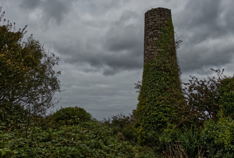
5/133 Chimney at SW 688 400
GV II
Chimney to former stone crusher of former tin mine; now derelict. 1888, for
Wheal Basset Mine. Coursed granite rubble. Tapered cylindrical form, now lacking
former brick upper stage. Included for group value with engine houses to west
and West Basset stamps to north-west. Reference: Palmer & Neaverson, op.cit.
Listing NGR: SW6880040000
External links are from the relevant listing authority and, where applicable, Wikidata. Wikidata IDs may be related buildings as well as this specific building. If you want to add or update a link, you will need to do so by editing the Wikidata entry.


Other nearby listed buildings
