Approximate Location Map
Large Map »
Latitude: 50.1816 / 50°10'53"N
Longitude: -5.1815 / 5°10'53"W
OS Eastings: 172962
OS Northings: 36134
OS Grid: SW729361
Mapcode National: GBR Z6.4Q1M
Mapcode Global: FRA 081J.TDD
Plus Code: 9C2P5RJ9+MC
Entry Name: Cross at Approximately 100 Metres South East of Tretheague House
Listing Date: 17 June 1988
Grade: II
Source: Historic England
Source ID: 1328426
English Heritage Legacy ID: 66279
ID on this website: 101328426
Location: Stithians, Cornwall, TR3
County: Cornwall
Civil Parish: Stithians
Traditional County: Cornwall
Lieutenancy Area (Ceremonial County): Cornwall
Church of England Parish: Stithians
Church of England Diocese: Truro
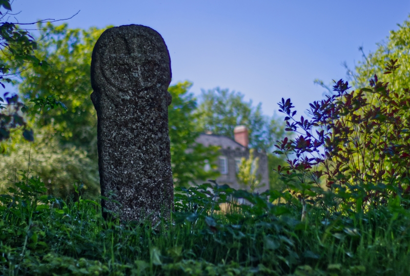
SW 73 NW STITHIANS TRETHEAGUE
2/294 Cross at approximately 100 metres
- south east of Trethea3ue House
GV II
Cross. Pre-Conquest. Tall granite wheelheaded monolith with lag on either side ofthe neck. There is a cross patee in relief to either face of the wheelhead and there is incised intersecting decoration to either side of the shaft.
Listing NGR: SW7296236134
External links are from the relevant listing authority and, where applicable, Wikidata. Wikidata IDs may be related buildings as well as this specific building. If you want to add or update a link, you will need to do so by editing the Wikidata entry.


Other nearby listed buildings
