Approximate Location Map
Large Map »
Latitude: 50.3975 / 50°23'51"N
Longitude: -4.2334 / 4°14'0"W
OS Eastings: 241360
OS Northings: 57678
OS Grid: SX413576
Mapcode National: GBR NR.SBFY
Mapcode Global: FRA 270Z.YB5
Plus Code: 9C2Q9QX8+2J
Entry Name: GWR Viaduct
Listing Date: 22 November 1982
Grade: II
Source: Historic England
Source ID: 1329263
English Heritage Legacy ID: 60402
ID on this website: 101329263
Location: Antony Passage, Cornwall, PL12
County: Cornwall
Civil Parish: Saltash
Traditional County: Cornwall
Lieutenancy Area (Ceremonial County): Cornwall
Church of England Parish: St Stephen-by-Saltash
Church of England Diocese: Truro
Tagged with: Railway viaduct
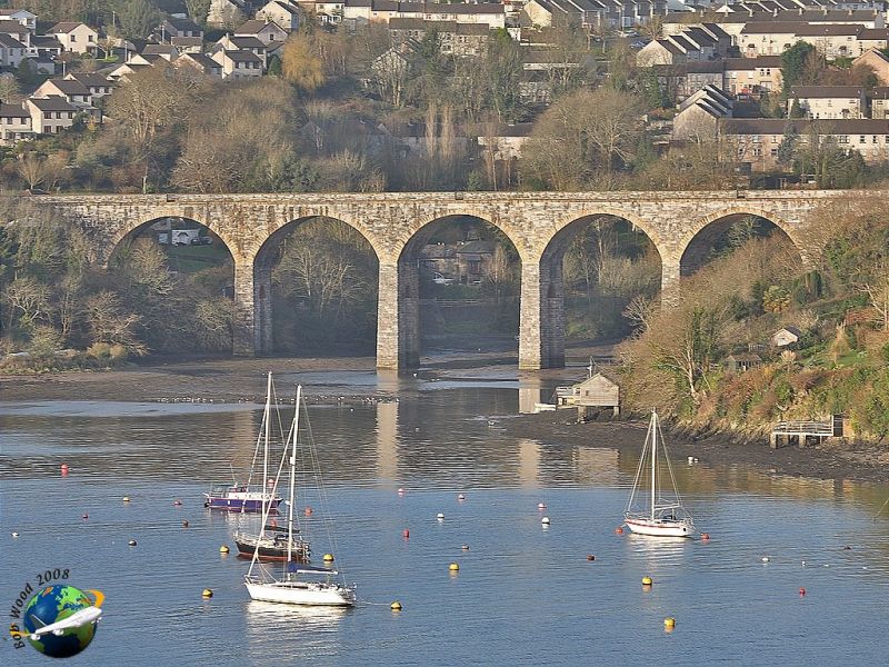
ANTONY PASSAGE
1.
5155
GWR Viaduct
SX 45 NW 4/48
II GV
2.
Possibly 1880s. The piers are of granite and support 8 arches in engineering brick.
The viaduct crosses the tidal mill (3 piers are in the pond). It is picturesquely
sited at the mouth of Forder Estuary, below Trematon Castle and high above the
Tidal Corn Mill.
Listing NGR: SX4137957457
External links are from the relevant listing authority and, where applicable, Wikidata. Wikidata IDs may be related buildings as well as this specific building. If you want to add or update a link, you will need to do so by editing the Wikidata entry.


Other nearby listed buildings
