Approximate Location Map
Large Map »
Latitude: 53.2016 / 53°12'5"N
Longitude: -2.1419 / 2°8'30"W
OS Eastings: 390615
OS Northings: 367181
OS Grid: SJ906671
Mapcode National: GBR 121.C86
Mapcode Global: WHBBW.2S9F
Plus Code: 9C5V6V25+J6
Entry Name: Macclesfield Canal Bridge Number 53
Listing Date: 14 June 1984
Grade: II
Source: Historic England
Source ID: 1329982
English Heritage Legacy ID: 58123
Also known as: Canal bridge number 53
Lockett's Bridge
ID on this website: 101329982
Location: Cheshire East, Cheshire, SK11
County: Cheshire East
Civil Parish: Bosley
Traditional County: Cheshire
Lieutenancy Area (Ceremonial County): Cheshire
Church of England Parish: Bosley St Mary the Virgin
Church of England Diocese: Chester
Tagged with: Bridge
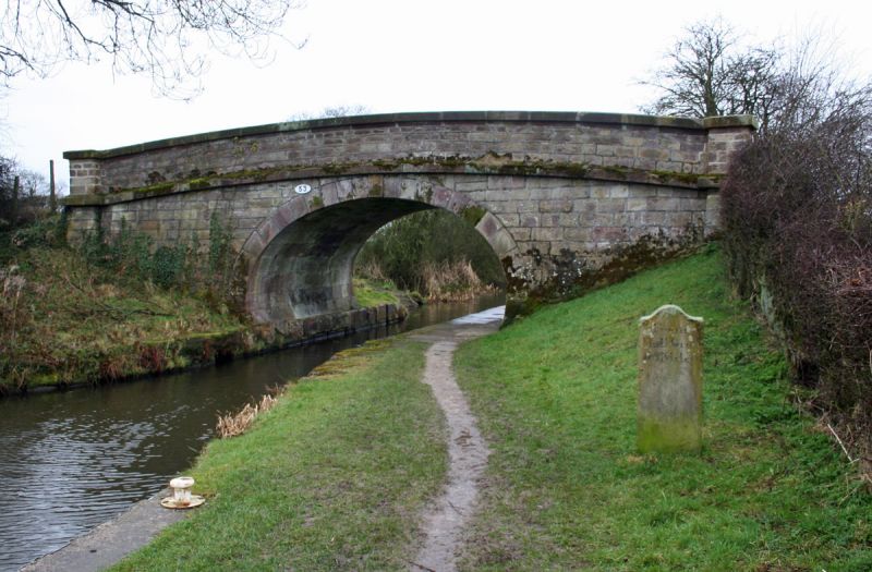
BOSLEY C.P., MACCLESFIELD CANAL,
SJ 96 NW; 1/12
Bridge Number 53
II
Farmland access bridge over canal, 1831. William Crosley engineer.
Of reddish-buff ashlar gritstone with horseshoe elliptical arch,
battered abutments curved in plan with square end-piers, plain band at
road level and stone parapets with plain copings.
Listing NGR: SJ9061367185
External links are from the relevant listing authority and, where applicable, Wikidata. Wikidata IDs may be related buildings as well as this specific building. If you want to add or update a link, you will need to do so by editing the Wikidata entry.


Other nearby listed buildings
