Approximate Location Map
Large Map »
Latitude: 52.3993 / 52°23'57"N
Longitude: 0.2636 / 0°15'48"E
OS Eastings: 554100
OS Northings: 280335
OS Grid: TL541803
Mapcode National: GBR M6H.FH6
Mapcode Global: VHHJ6.JY6K
Plus Code: 9F4297X7+PC
Entry Name: Nos. 16 and 18 High Street (including Steeple Gate)
Listing Date: 23 September 1950
Last Amended: 13 July 2017
Grade: II*
Source: Historic England
Source ID: 1331714
English Heritage Legacy ID: 48742
ID on this website: 101331714
Location: Ely, East Cambridgeshire, CB7
County: Cambridgeshire
District: East Cambridgeshire
Civil Parish: Ely
Built-Up Area: Ely
Traditional County: Cambridgeshire
Lieutenancy Area (Ceremonial County): Cambridgeshire
Church of England Parish: Ely
Church of England Diocese: Ely
Tagged with: Gate
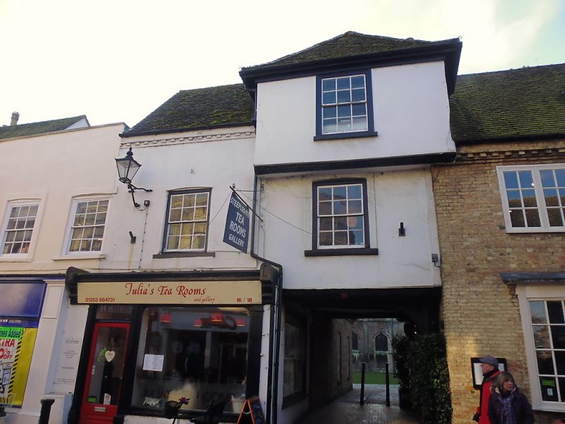
No. 16 is an early-C16 timber-framed building which incorporates Steeple Gate, a pedestrian gateway to Ely Cathedral, while No. 18 is an C18 shop, both with later alterations. Beneath the two buildings, which are now (2017) occupied by a cafe, is C14 lierne vaulted cellar.
No. 16 is an early-C16 timber-framed building which incorporates Steeple Gate, a pedestrian gateway to Ely Cathedral, while No. 18 is an C18 shop, both with later alterations. Beneath the two buildings, which are now (2017) occupied by a cafe, is C14 lierne vaulted cellar.
MATERIALS: No. 16 is timber-framed and No. 18 is of brick with some re-used medieval ashlar, both being plastered and with tiled roofs.
PLAN: the two buildings form part of an irregular row, aligned east to west, on the south side of the High Street.
EXTERIOR: No. 16 forms the right-hand side of the composition and is of three storeys with an open gateway (Steeple Gate) to the ground floor and jettied upper storeys. To the north-west and south-west corners of the gateway there are large posts of which the north-west post has curved braces rising to support the western cross rail and northern jetty plate. The braces to the south-west post are now missing, while the posts and braces on the east side were removed when No. 18 was rebuilt in the C18. The bressumers to the two jettied upper storeys are decorated with a foliate design which incorporates renaissance motifs, including grotesque faces. Both upper floors have a single six-over-six unhorned sash in a flush cased frame.
The ground floor of No. 18, which is of two-storeys, has a C19 wooden shop-front with plain pilasters, a shallow fascia between console brackets and a C20 door to the right-hand side of a plate glass window. On the first floor there is a six-over-six unhorned sash in a flush cased frame. Projecting from the wall at the left-hand side of the window is a C20 cast-iron lamp. Above is a dentilled eaves cornice.
The rear of No. 16 also has two heavily decorated bressumers with renaissance motifs. To the first floor there is a C16 oriel window with moulded mullions and transom and a leaf-ornamented sill which is supported on brackets with a floral motif in the spandrels. Above, the second floor has a C19 six-over-six horned sash in a flush cased frame. Projecting from the rear of No. 18 is a late-C20 range of one-and-a-half storeys. It is constructed from gault brick and has a roof of reclaimed clay tiles and modern tiles. Both its west and south sides have two six-over-six horned sashes with cambered heads; those on the south side are separated by a doorway. The west side of the attic storey has two box dormers while the south side has a single box dormer, all with three-over-three horned sashes. The first floor of the C18 range was partially rebuilt in the late C20, including the removal of the stack, and has a dentilled eaves cornice of this date. Above, there is a late-C20 box dormer with a three-over-three horned sash to the attic.
INTERIOR: lying beneath the two buildings is a C14 lierne vaulted cellar with deeply chamfered freestone ribs springing from semi-octagonal stone vaulting shafts. It is of three irregular bays in width, with the western and central bays being roughly equal in size while the eastern bay is narrower. The walls are constructed from re-used stone and brick, of which some of the re-used stone includes sections of column shafts that have profiles suggesting a C12 date for the original working of the stone. The walls themselves have blind arches of moulded and chamfered brick, including some late-C20 reconstruction, while the webbing between the ribs is also of brick with some small patches of render still visible. The transverse rib between the central and western bay contains the faint remains of a decorative paintwork scheme in the form of a series of red flowers formed of five separately articulated petals. Faint traces of a blue background with some form of scrolled or curving motif appears to be part of the same scheme. The cellar's eastern wall is formed of large pieces of rubble stone, but the differentiated use of stone for freestanding elements and brick for engaged elements suggests that the cellar originally continued further east and that the wall is therefore a later addition. The current easternmost transverse rib is of stone, which suggests that this rib originally formed a freestanding part of the vault, while the east face of the shaft appears to be chamfered. The vaulting shaft in the north wall of the east bay includes the side of an arched stone opening, possibly indicating the position of a former doorway. Running from the south of the east bay is a narrow passageway constructed from large rubble stone blocks with some brick, most likely leading to a former staircase. The west wall of the western bay, which appears always to have represented the final bay in this direction, has been reconstructed in modern brick. In the north and south walls of this bay there are two recesses. The southern recess extends the full width of the bay and has an arched head formed of the same chamfered brick as the blind arcading, but the opening is slightly lower, with a depressed-arched head. The northern recess is narrower with its outer sides stepped in from the adjacent vaulting supports. The lower sections of its sides are formed of large sections of worked squared stone while the upper sections and the depressed-arched head are of chamfered brick, the latter with a central stone voussoir. Above is a small light well which has been partially rebuilt in modern brick. The cellar floor is of C19 gault and red brick with a central drainage channel. Running around the sides of the east and central bay is a low level plinth of late-C20 brick with a tile top. The eastern part of the southern wall of the central bay has largely been rebuilt as part of the insertion of a late-C20 entrance door, with a late-C20 brick wall forming the corridor from the staircase.
The ground floor of the C18 front section to No. 18 has a contemporary ceiling beam to a plastered ceiling. The rear section is entirely late-C20 in character, with a bare brick wall and machine-sawn ceiling joists. Above, the first-floors of Nos. 16 and 18, which are accessed by a late-C20 staircase, have been amalgamated, with the division between the two buildings marked by a C16 wall post and cross beam. Otherwise, all walls and ceilings are plastered and painted. The roof structure to No. 16 is a late-C20 softwood replacement, though some framework from the C18 roof still survives in situ.
The present city of Ely rises 20m above the surrounding fen on an island of Kimmeridge clay. Although well connected by river and waterways, until the C17 only causeways connected the island to the mainland, and in the early years of Christianity in England its isolation made it an ideal refuge for those seeking a secluded monastic life. The first successful attempt to establish a religious settlement here was made by Etheldreda in c673, re-endowed by King Edgar 100 years after its destruction by the Danes in 870. Despite threats of further invasion in the C11, and later political turmoil, this monastery survived until its dissolution in 1539. The presence of a monastic community occupying substantial buildings required the support of a lay community, and as that grew, so did the needs of the lay-people for accommodation and services. A detailed survey of 1416 recorded 457 buildings and described an established street pattern; by 1563 the number of households had grown to 800. Despite this growth in population, John Speed’s map of Ely, published in 1611/12, is very similar in both layout and extent to that of the first edition Ordnance Survey (OS) Map of 1885, where the only significant expansion is towards the railway (1845); however, in Speed’s map, houses lining the streets enclose spaces of apparently horticultural and even agricultural production, and while these are still present on the 1885 map they have been pushed to the margins of the city. These maps graphically illustrate the continuing importance of agriculture and its related industries in the early C17 and beyond, and also show that the later growth in population took place mainly within the confines of the early city street plan. Before the later C19 the only significant rival to agriculture was the pottery industry, in production from the C12 to 1860.
Following the dissolution of the monastery, Ely remained the centre of the diocese, but the loss of the community, and of pilgrims to the shrine of St Etheldreda, would have had a considerable impact on the city’s economy. The consequent decline in management of the fen and its waterways led to an increase in flooding, and attempts at drainage in the C17 and C18 seem to have had limited effect, creating constraints on the ability of the city to thrive. Successive literary travellers commented on the poor drainage, including Celia Fiennes in the mid-C17, who described the city as a “perfect quagmire”, and Daniel Defoe in the early C18, who noted both the city’s market gardens and its overflowing wells. By the mid-C19 the city was in a state of recovery and regeneration: several possible contributory factors include successful drainage, enclosure (1848) and the arrival of the railway with the opening of the Cambridge to Ely line in 1845. This was followed slightly later by other lines, making the city a transport hub. Despite this, the physical expansion of Ely beyond its medieval core was slow through the mid-C20, accelerating through the late C20 and into the C21, as Ely developed as a dormitory town for Cambridge.
Nos. 16 and No.18 High Street, of which the former includes Steeple Gate, a pedestrian gateway to Ely Cathedral precinct, form part of an irregular row of buildings which run almost continuously along the south side of the street, from the Almonry (Grade I) in the east to its junction with Minster Place in the west. Along with the highway to the north, which was known as Stepilrowe (Steeple Row) during the medieval period, the narrow strip of land on which the two buildings stand is bounded to the south by the former monastic precinct. The precinct boundary wall, which was roughly aligned with the rear walls of the buildings that now stand on the south side of the High Street, was dissected by three gateways. Steeple Gate, the westernmost gate of the three, appears to have been referred to as the ‘steeple’ or ‘campanile’ throughout the medieval period, possibly suggesting that its original form was that of a tower. In around 1359, the parish church of Holy Cross, later Holy Trinity, was built against the north wall of the cathedral's nave, with a burial ground laid out on land between the north side of the church and the north boundary wall of the monastic precinct. Documentary evidence states that the ‘steeple’ was taken down in 1354-5 at a relatively low cost, possibly indicating that it was constructed from timber. However, some form of gateway was retained to provide access to the new church and burial ground, along with the original name, though its exact form is unknown. By the early C15, as documented in a rental survey of 1416/17, the narrow strip of land between the precinct boundary wall and Steeple Row had been developed with a row of tenements. Owned by the Prior of the Abbey or the Bishop, the tenements were probably built during the C14, as a lierne vaulted cellar of this date survives beneath the two buildings. During the C16, Steeple Gate and the adjoining tenements were substantially rebuilt in timber, probably reflecting a significant reorganisation of the premises along the High Street following their sale by the Crown after the Dissolution. In the C18, No. 18 was completely rebuilt in brick, incorporating some re-used medieval ashlar, while No.16 was re-roofed. It is possible, as suggested by the modern street frontage, that No. 18 may have functioned with No. 20 from this period, as the first-floor window openings have a consistent C18 form and window fittings. Nos.18 and 20 were probably subdivided in the C19, possibly just before Nos. 16 and Nos. 18 became a single shop unit, being occupied by Jeremiah Giscard, a watch and clock seller. At some point from the C16 onwards, the cellar beneath No. 16 was reduced in size by at least one bay. While this is difficult to precisely date, it is likely to correspond to one of the phases of significant alteration to the upper structures in the C16, C18 or C19. During the C20, Nos. 16 and 18 were occupied by a butchers, a florists and a chemists. In 1978, they were restored and opened as a tea room and craft shop. The restoration work included the excavation of the C14 cellar, the complete rebuilding of the C16 range at the rear of No. 18 and the replacement of the C18 roof structure above No. 16. The two buildings, which were bought by the Dean and Chapter of Ely Cathedral c2009, are now (2017) occupied by a cafe.
No. 16 High Street, an early-C16 timber-framed building incorporating Steeple Gate, a pedestrian gateway to Ely Cathedral, and No. 18 High Street, an C18 shop, both built over a C14 lierne vaulted cellar, are listed at Grade II* for the following principal reasons:
* Architectural interest: the lierne vaulted cellar and double jettied gateway exhibit high-quality craftsmanship in their construction, use of materials and detailing;
* Survival of early fabric: for the retention of an extensive amount of medieval fabric in the form of a lierne vaulted cellar, the detail of which allows for the theoretical reconstruction of the size, form and possible status of the building at that date;
* Historic interest: the C14 fabric of the lierne vaulted cellar may confirm the early emergence of Ely’s street pattern, established by the early C15 and described on John Speed’s map of 1610/1611. Phases of rebuilding from the C16 onwards illustrate the city’s emerging townscape, and the evolution, distribution and role of commerce in the city up to the C18 into the C19 and C20;
* Group value: it has a strong visual and functional relationship with Ely Cathedral (listed Grade I), to which Steeple Gate provides pedestrian access from the High Street, along with a number of listed buildings on the High Street, the closest of which are Nos. 12 and 14, and Nos. 20 to 24A, all listed at Grade II.
External links are from the relevant listing authority and, where applicable, Wikidata. Wikidata IDs may be related buildings as well as this specific building. If you want to add or update a link, you will need to do so by editing the Wikidata entry.


Other nearby listed buildings
