Approximate Location Map
Large Map »
Latitude: 52.3983 / 52°23'53"N
Longitude: 0.2551 / 0°15'18"E
OS Eastings: 553524
OS Northings: 280196
OS Grid: TL535801
Mapcode National: GBR M6G.R90
Mapcode Global: VHHJ6.CZPC
Plus Code: 9F4297X4+82
Entry Name: Dove house to St John's Farm
Listing Date: 23 September 1950
Last Amended: 13 December 2017
Grade: I
Source: Historic England
Source ID: 1331739
English Heritage Legacy ID: 48779
ID on this website: 101331739
Location: Ely, East Cambridgeshire, CB6
County: Cambridgeshire
District: East Cambridgeshire
Civil Parish: Ely
Built-Up Area: Ely
Traditional County: Cambridgeshire
Lieutenancy Area (Ceremonial County): Cambridgeshire
Church of England Parish: Ely
Church of England Diocese: Ely
Tagged with: Dovecote
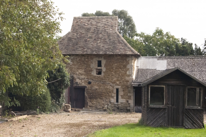
Dove house, documented as such from the C17 but with medieval fabric possibly from the former Hospital of St John the Baptist and St Mary Magdelene incorporated into its fabric.
Building: dove house, documented as such from the C17 but with medieval fabric possibly from the former Hospital of St John the Baptist and St Mary Magdelene incorporated into its fabric.
Materials: constructed largely of rubble and Barnack stone with limestone ashlar and clunch dressings. The roof was of plain tiles of which some survive on the northern side of the hipped roof.
Plan: the dove house is square in plan.
Exterior: the dove house is a square building rising through two storeys with a pyramidal tiled roof with gablets to the north and south sides. The earliest in-situ fabric in the extant building appears to be the principal walling of the north and east elevations. This is of rubble stone, with dressed stone at the corner junction of the two elevations and in other features. At the base of the east elevation is the remains of an arcade with two stone arches built into the walling. The northern arch is supported on two, stone piers which are now largely below ground level, but which were uncovered during recent works on the building. These comprise a square central pillar with semi-circular pilasters on their inner edges (the only observable sides). These support a two-centre arch of dressed stone. The bases of the arch are located poorly on the tops of the piers, and it is possible that the piers belong to an earlier building, with the arches built (or rebuilt) later. The arch is infilled, but appears originally to have been open. The lower portion of the southern arch was less visible at the time of the site visit and the upper part is more obscured by its later infill. It appears to have comprised the same two-centre dressed stone arch, but it is not clear if this arch was also open originally. Above the arcade the east elevation is without any further features.
The north wall appears to have no corresponding arcade, but there are traces of a blocked opening at the current ground-floor level, and at first-floor level it has one definite blocked opening, with possibly a further blocked opening immediately to its east. The ground-floor opening survives only as a relieving arch of rubble stone. As with the arcade on the east elevation, there is likely to have been an arched door or window below; the narrow span of the arch suggests a window is more likely. At first-floor level on the western edge of the north elevation, is a further blocked opening. indicated by a stone relieving arch, similar to that at ground-floor level. Below this are two dressed stones which may form part of the eastern window jamb, and further dressed stones which appear to form part of a sill. To the east of this, another blocked opening is indicated principally by a row of three dressed stones probably forming a cill. Above there are no observable further elements, but it may be that upper sections were removed as part of later remodelling of the wall. Although tentative, the presence of a doorway at this level would indicate some means of external access to the first-floor. The window immediately adjacent to this suggests that this is less likely to have been via an attached range to the north, but perhaps instead by means of an external stair against the wall. The truncated window opening and the lack of quoins on the north-west corner indicate that originally the north wall continued westwards, as it does at ground-floor level, with no straight joint between the elevation and the north wall of the lean-to shed or adjacent walkway. This is formed of the same type of stonework, but appears to be without any further features; indicating that the two extant medieval walls were part of a longer range. This is borne out by the early plan of the site.
The south elevation is partly obscured by the adjoining garage. It has one central upper window partly covered by the garage roof. Internally the opening has the remains of wide splays, and the tall, narrow opening has re-used limestone and clunch dressings. It is blocked with modern brickwork.
The west wall has three openings, one of which appears to be a modern doorway replacing the blocked doorway in the north elevation. The extant doorway is perhaps late C19 or early C20 century, but may reflect an alteration or widening of an earlier feature, as this seems the most logical side for an entrance once the earlier ranges abutting this elevation were demolished. Adjacent to the doorway there is a stone-dressed ventilation loop, the only window opening to the former ground floor. It has a rebated reveal and wide internal splays. The upper window in the west elevation was wide and of domestic proportions. The original width of the opening is defined by the stone lintel, with provision for chamfered jambs. The jambs of clunch have partly weathered away on the north side and been roughly replaced with two pieces of chamfered limestone reducing the width of the window, and a stone sill inserted at the same time reduced the height. The blocking beneath the sill is brickwork. The top part of the opening has also been blocked, with clunch, and by a lintel housed in the south jamb. The opening at ground-floor level represents the best survival in the building with evidence that the inner edge of the surround has a slight rebate on all four sides. This may have been designed to take some form of external shutter. The first-floor openings are too weathered or damaged to establish whether they took the same form.
Interior: access to the interior was limited at the time of both building surveys (Heywood, S 2014) due to storage of equipment, but the principal characteristics of the interior are the evidence of the former suspended floor, with joist holes evident. The internal face of the north and west walls is missing with just the core showing in the west wall. In his report (2014), Stephen Heywood records evidence of smooth plasterwork which adds weight to his interpretation of a domestic function for the former building.
The internal face of the northern elevation displays the rubble voussoirs of the arch over the ground-floor doorway. The roof structure is of hipped construction with gablets to the north and south, perhaps to allow ventilation. The structure relies on a ring of purlins on which the rafters rest and from which the vertical gablets are built. The undersides of the rafters have the nail holes for lathes showing that the ceiling has been plastered. The pigeon loft floor is of boards which were held up by collars linking opposed purlins. Only one of these survives in-situ. There is one tying collar, halved to a pair of rafters. The scantling is light but not unusual for the C16 century.
On the north wall, the soffit and jamb of the blocked opening are visible on the interior and the rubble voussoirs of the arch over the ground-floor doorway can be clearly seen. The opening has been blocked and then further disturbed by roughly built brick work over some slightly projecting rubble masonry, with two pieces of re-used ashlar. It is probable this is part of major vertical crack in the wall, repaired with brick internally and stone rubble externally.
The present farm of St John’s, Ely occupies the site of a medieval hospital, institutions established to care for the infirm poor (and also other groups of people in need) from the early middle ages until the dissolution of the monasteries in the C16. Typically, they formed a group of buildings housing a religious or secular institution which provided both spiritual and medical care. The idea for such institutions originated in the Anglo-Saxon period, although the first definite foundations were created by Anglo-Norman bishops and queens in the C11. Documentary sources indicate that by the mid-C16 there may have been about 1000 foundations in existence, most of which were run by a religious community headed by a prior or master. Half of the hospitals present at that time were suppressed as part of the Dissolution of the Monasteries in 1539. Some smaller institutions survived until 1547, when they were dissolved by Edward VI, but others continued in use as almshouses.
Buildings of hospital complexes tended to adopt a monastic form, with a similar range of buildings, but with the nave or body of the church containing the infirmary hall and its inmates, their beds placed in the aisles. The chapel itself was generally confined to the east end of the building, often a single cell, perhaps with a sacristy attached. Other ranges included cloisters, refectory and dormitory, accommodation for the master and guests, as well as service buildings, depending on the size of the hospital. The complex as a whole would have been surrounded by a wall or earthwork enclosure.
The present farm known as St John’s is thought to occupy the site of the Hospital of St Mary Magdelene, first recorded in 1225 when it was gifted the church at Littleport. In about 1251 this hospital was merged with a second, St John the Baptist, by Bishop Hugh Northwold. It then become the Hospital of St John the Baptist and St Mary Magdelene. The bishop also drew up a simple rule for communal living: the hospital was to be placed under the care of a Master, and was to have no more than 13 brethren, both lay and clerical. The Master was allowed a room of his own, but all others were to share a single dormitory, and all, including the Master, were to eat together in one refectory.
Specific hospital buildings mentioned in Bishop Fordham’s revised rule of 1303 include a chapel, refectory, dormitory and cloister, as well as the master’s own chamber. Guests are likely to have been separately accommodated. Bishop Northwold’s Rule of 1240 also made provision for the burial of the dead, specifying that the poor who died in the Hospital were to be buried in the parish churchyard, but that the brethren, both lay and clerical, were to be buried in the Hospital graveyard. The only reference to the buildings of St John’s Hospital in the earlier Rule is to a chapel, to be left at the disposition of the Sacrist of the monastery.
The C14 was a time of prosperity for the hospital, but by 1454 it had fallen into poverty. The Mastership was granted as a sinecure to Bishop Dunkeld, and it appears that by the late C15 and into the C16 many of the buildings had fallen into disuse. The dissolution of the hospital, however, did not take place until 1561, when it was presented by Queen Elizabeth I to Clare Hall (later Clare College) for the endowment of 10 scholarships. The farm and the Hospital were subsequently let, recorded in a rental of 1561. A lease of 1620, to John Orwell of Ely, a gentleman, describes both a mansion house and ‘a house called the Hospital with a yard thereto belonging’.
The earliest visual record of buildings on the site of the hospital is Speed’s 1607 sketch map of Ely. This depicts four buildings within an enclosed area of land bounded by to the north, west, and east by the roads currently known, respectively, as West End, St John’s Road and Cambridge Road. Three of the buildings are shown centrally placed in the northern part of the site, apparently arranged around an open courtyard, with gatehouses centrally placed to north and south; there is a fourth building set against the east wall. In the published version of 1610/11, the south boundary is obscured by the map key, but the north gatehouse is present.
The most detailed record of the main complex of buildings to the north is a plan thought to date to the C17, but which may be as late as the early C18. This records a number of buildings grouped around a courtyard, possibly part of the former cloister, and describes an apparently high status dwelling, compatible with the standing of the C17 tenant, John Orwell, but perhaps in the early stages of decline. This includes a partly ruinous building to the south, described as a ‘chappell without any roof’, with single storey service buildings attached to the west. Two further former hospital ranges, the east side of the cloister and a building to the north (the latter now a two storey service building) are shown as converted to domestic use, the northern building described as having ‘two large chambers over a kitchen and large parlour’, the parlour ‘now used as a dairy’. The plan also illustrates a substantial two storey building, west of the cloister and attached to the south of the two storey service building, its ground-floor rooms described as ‘The Hall’ and ‘a little parlour’, with two chambers and a narrow gallery over. A porch with a staircase, set in the east corner where the two buildings meet, provides the only access between them.
The immediate surroundings of the buildings are also described. The property boundary to the north and east which separates the north complex from ‘the towne street’ is a stone wall, with a short section of mud or clay fence. Immediately to the west of the surviving two-storey service building is the entrance from the street, running beside and around the south of the hall into the court. To the south of the ‘chappell’ is the garden and to the east and north is an orchard, on the west side of which, just east of the chapel, is the dove house. A ‘pale’ to the south divides the orchard and garden from ‘the close’. The orchard is still described as such on the 1st edition Ordnance Survey map, but was developed for housing in the late C20, along with the east side of the close.
Of those buildings shown on the early plan, the two-storey service building is the only hospital structure that remains (NHLE 1126455), though radically altered. This seems to represent the remains of the hospital’s infirmary hall, built in the C13, and probably originally a four or five bay building. It was converted for domestic use in the late C15 or early C16, when it was reduced to three bays, and its north (and a possibly south) aisle demolished. A survey of the building undertaken by Historic England in 2014 suggests that its fabric demonstrates two phases of alteration, the first when its mastership was held by Bishop Dunkeld, before its dissolution but following the loss its brethren, the second after its dissolution, when it became part of a more extensive high status dwelling.
The surviving post-dissolution dove house (NHLE 1331739), the subject of this list entry, is also shown on the plan. It is clear from the documentary history that a dove house sat on the south-east side of the main hospital complex from the C17. This is shown consistently on subsequent plans and successive construction and reconstruction of ranges to its north, west and south, go some way to explain the complex fabric evidence extant today. The earliest fabric is understood to date to the medieval period but the current square plan form is believed to be the result of a late medieval or early modern phase when an entrance was created on the east side. Evidence also implies that the roof level was possibly higher at this time and that the current form of the roof was the result of C17 or C18 phase of alteration and typical of dove houses in the east of England at that time.
About 120m south-west of the service building is a Grade I stone barn (NHLE 1136456) and three further agricultural buildings. Although this is referred to as the second complex, the other structures associated with the barn are relatively modern agricultural buildings. The barn is the only one of these structures to contain early fabric. Traditionally described as a chapel, neither its purpose nor its relationship to the hospitals of either St John or St Mary Magdelene is understood. It lies within the historic curtilage of St Mary’s, defined by a ditch to the south, but contains early C13 fabric, apparently predating the merger of the two hospitals. Although evidently a freestanding structure, it is likely to have been associated with other buildings.
By 1792 the cloisters and ruinous chapel had gone, as well as the later hall, and had been replaced by the present farmhouse in the north complex. The buildings are described in a survey of that date, which also refers to an old stone building with two rooms and a dairy. This is evidently the surviving two-storey service building. The document also refers to four barns, which may have been located in the complex to the south.
The Tithe map of 1838 and later C19 Ordnance Survey mapping show relatively minor changes to both the south and north complexes. A lean–to was added to the farmhouse (NHLE 1167882) between 1838 and 1848, and there were alterations to the arrangement of farm buildings in the south complex. These are shown on the Ordnance Survey map of 1885. Later alterations include the removal of a structure attached to the south of the west end of the stone barn in the south-west complex.
Dove house at St John's Farm, documented as such from the C17 containing medieval fabric from the former Hospital of St John the Baptist and St Mary Magdelene, is listed at Grade I for the following principal reasons:
* Architectural interest: the post-dissolution dove house contains complex fabric evidence dating from the medieval period but spanning construction and reconstruction of ranges to its north, west and south to the present day (2016) which contributes to the understanding of the wider hospital complex and its evolution;
* Historic interest: as a post-dissolution dove house standing on the site of and incorporating fabric from the medieval hospital but representing a period when the hospital became part of a more extensive high status dwelling. In combination with the C17 or early C18 plan, it adds further to the understanding of the evolution, location and possible arrangement of other buildings in the wider complex;
* Group value: it has a very strong group value with the three other Grade I listed buildings, the Grade II wall to St Johns Farm, and the scheduled site of the Hospital of St John the Baptist and St Mary Magdelene all of which are understood to contain medieval fabric. Together they form a historically coherent group which reflect changes to the status and use of the site over 800 years.
External links are from the relevant listing authority and, where applicable, Wikidata. Wikidata IDs may be related buildings as well as this specific building. If you want to add or update a link, you will need to do so by editing the Wikidata entry.


Other nearby listed buildings
