Approximate Location Map
Large Map »
Latitude: 51.5741 / 51°34'26"N
Longitude: -0.7794 / 0°46'45"W
OS Eastings: 484684
OS Northings: 186840
OS Grid: SU846868
Mapcode National: GBR D5W.7RD
Mapcode Global: VHDWB.FPTP
Plus Code: 9C3XH6FC+J6
Entry Name: 47-53, Cambridge Road
Listing Date: 31 January 1974
Grade: II
Source: Historic England
Source ID: 1332378
English Heritage Legacy ID: 46182
ID on this website: 101332378
Location: Marlow, Buckinghamshire, SL7
County: Buckinghamshire
Civil Parish: Marlow
Built-Up Area: Marlow
Traditional County: Buckinghamshire
Lieutenancy Area (Ceremonial County): Buckinghamshire
Church of England Parish: Great Marlow with Marlow Bottom, Little Marlow and Bisham
Church of England Diocese: Oxford
Tagged with: Building
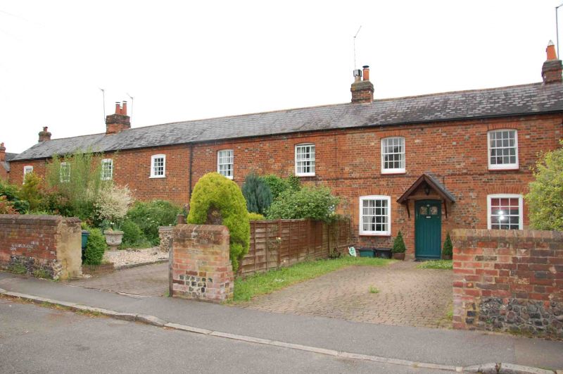
CAMBRIDGE ROAD
1.
1385
Nos 47 to 53 (odd) 47 to 53 (odd)
SU 8486 1/87
II
2.
Late C18 or early C19. Row of terraced cottages in C18 tradition. 8
windows. Segmental arches. Glazing bars intact. Plain doors with small
flat hoods. Old slate roof.
Listing NGR: SU8468486840
External links are from the relevant listing authority and, where applicable, Wikidata. Wikidata IDs may be related buildings as well as this specific building. If you want to add or update a link, you will need to do so by editing the Wikidata entry.


Other nearby listed buildings
