Approximate Location Map
Large Map »
Latitude: 53.3687 / 53°22'7"N
Longitude: -2.0001 / 2°0'0"W
OS Eastings: 400090
OS Northings: 385757
OS Grid: SK000857
Mapcode National: GBR GYGH.S4
Mapcode Global: WHBB5.7LTC
Plus Code: 9C5V9X9X+FX
Entry Name: 66, High Street
Listing Date: 19 September 1977
Grade: II
Source: Historic England
Source ID: 1334770
English Heritage Legacy ID: 81829
ID on this website: 101334770
Location: Hidebank, High Peak, Derbyshire, SK22
County: Derbyshire
District: High Peak
Civil Parish: New Mills
Built-Up Area: New Mills
Traditional County: Derbyshire
Lieutenancy Area (Ceremonial County): Derbyshire
Church of England Parish: New Mills St George
Church of England Diocese: Derby
Tagged with: Building
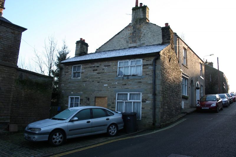
NEW MILLS HIGH STREET
1.
5172
(East Side)
No 66
SK 0085 1/93
II GV
2.
C18 cottage of 2 storeys in coursed stone, rendered to front, with stone slate roof.
2 windows, that to right probably originally had mullions. Early C19 shop front
to right on ground floor has entablature and cornice, modern door. Plinth. Included
for group value.
Listing NGR: SK0009085757
External links are from the relevant listing authority and, where applicable, Wikidata. Wikidata IDs may be related buildings as well as this specific building. If you want to add or update a link, you will need to do so by editing the Wikidata entry.


Other nearby listed buildings
