Approximate Location Map
Large Map »
Latitude: 53.3795 / 53°22'46"N
Longitude: -1.9455 / 1°56'43"W
OS Eastings: 403724
OS Northings: 386965
OS Grid: SK037869
Mapcode National: GBR GYVC.L7
Mapcode Global: WHBB6.2BV0
Plus Code: 9C5W93H3+RR
Entry Name: The Bridge
Listing Date: 12 April 1984
Grade: II
Source: Historic England
Source ID: 1334812
English Heritage Legacy ID: 82081
ID on this website: 101334812
Location: Hayfield, High Peak, Derbyshire, SK22
County: Derbyshire
District: High Peak
Civil Parish: Hayfield
Built-Up Area: Hayfield
Traditional County: Derbyshire
Lieutenancy Area (Ceremonial County): Derbyshire
Church of England Parish: Hayfield St Matthew
Church of England Diocese: Derby
Tagged with: Bridge
SK 03 86 PARISH OF HAYFIELD CHURCH STREET
7/I0I
The Bridge
GV II
Bridge. Dated I837. Coursed dressed gritstone. Depressed arch with
projecting keystone. Approximately fouryards wide. Stringcourse above.
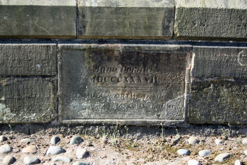
Low parapet walls with dressed copings. Plaque on road side of north wall
states 'Erected Anno Domini MDCCCXXXVII / Samuel Worth Architect / George
Bamford Builder'.
Listing NGR: SK0372486965
External links are from the relevant listing authority and, where applicable, Wikidata. Wikidata IDs may be related buildings as well as this specific building. If you want to add or update a link, you will need to do so by editing the Wikidata entry.


Other nearby listed buildings
