Approximate Location Map
Large Map »
Latitude: 53.3017 / 53°18'5"N
Longitude: -1.4739 / 1°28'25"W
OS Eastings: 435160
OS Northings: 378430
OS Grid: SK351784
Mapcode National: GBR LZ48.Q5
Mapcode Global: WHDF2.B8DQ
Plus Code: 9C5W8G2G+MF
Entry Name: The Old Grammar School
Listing Date: 7 July 1989
Grade: II
Source: Historic England
Source ID: 1335485
English Heritage Legacy ID: 79502
ID on this website: 101335485
Location: Dronfield, North East Derbyshire, S18
County: Derbyshire
District: North East Derbyshire
Civil Parish: Dronfield
Built-Up Area: Dronfield
Traditional County: Derbyshire
Lieutenancy Area (Ceremonial County): Derbyshire
Church of England Parish: Dronfield St John Baptist
Church of England Diocese: Derby
Tagged with: School building
PARISH OF DRONFIELD CHURCH STREET
SK 37 NE
6/22
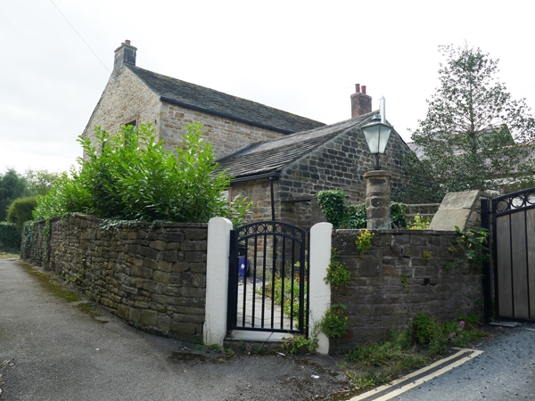
The Old Grammar School
No 18 Church Street
II
House, formerly school. C17 or earlier with alterations in C18
and C19. Roughcast coal measures sandstone, gable and sidewall
ashlar stacks, some with brick tops. Plain gables and a stone
slated roof. Two storeys, four bays, with sash windows with
glazing bars to the upper sashes, with painted flush stone
surrounds. Two ground floor windows retain glazing bars to both
sashes. Doorway to east end with flush stone surround, and a
C20 glazing door. Single storey range at right angles to the
rear, with low pitched roof. Interior. Large ground floor
room, with evidence of former openings suggesting that a cross
passage separated a single end bay from an open schoolroom. The
reveals to the openings contain C17 graffiti. First floor
fireplace with C17 surround. The school was founded in 1568 in
accordance with the provisions of the will of Henry Fanshawe,
the Remembrancer of the Court of the Exchequer to Elizabeth 1st.
An inquisition held at Derby in 1590 refers to 'a house newly
built called Le Scholehouse with 1 1/2 acres of land and a cottage
adjoining' being conveyed to the Vicar and Churchwardens.
Listing NGR: SK3516078430
External links are from the relevant listing authority and, where applicable, Wikidata. Wikidata IDs may be related buildings as well as this specific building. If you want to add or update a link, you will need to do so by editing the Wikidata entry.


Other nearby listed buildings
