Approximate Location Map
Large Map »
Latitude: 54.9727 / 54°58'21"N
Longitude: -2.95 / 2°56'59"W
OS Eastings: 339287
OS Northings: 564644
OS Grid: NY392646
Mapcode National: GBR 7BVY.47
Mapcode Global: WH7ZP.N8GP
Plus Code: 9C6VX3F2+32
Entry Name: Westlinton Bridge
Listing Date: 16 January 1984
Grade: II
Source: Historic England
Source ID: 1335593
English Heritage Legacy ID: 77981
ID on this website: 101335593
Location: Westlinton, Cumberland, Cumbria, CA6
County: Cumbria
District: Carlisle
Civil Parish: Westlinton
Traditional County: Cumberland
Lieutenancy Area (Ceremonial County): Cumbria
Church of England Parish: Blackford St John the Baptist
Church of England Diocese: Carlisle
Tagged with: Road bridge
NY36 SE
7/190
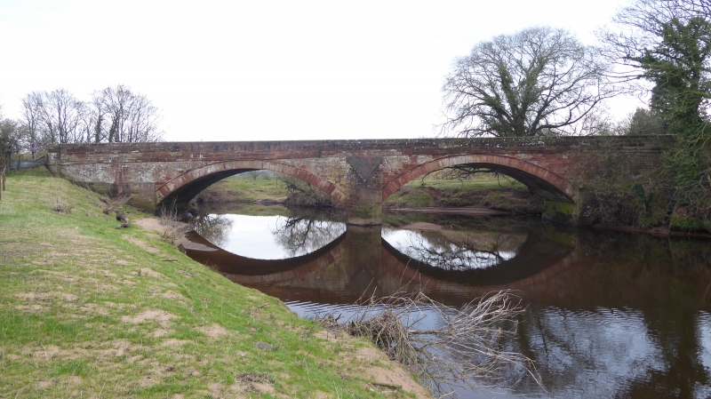
WESTLINTON
Westlinton Bridge
II
Road bridge. Probably 1793 for the Carlisle-Longtown Turnpike. Red sandstone
ashlar. 2 segmental arches with central pier having pointed cutwaters. Abutments
have chamfered plinth and cylindrical end piers. String course with chamfered
coped parapet. Abutment inscription CEMENT POINTED 1891. This bridge is partly in
Arthuret CP.
Listing NGR: NY3928764644
External links are from the relevant listing authority and, where applicable, Wikidata. Wikidata IDs may be related buildings as well as this specific building. If you want to add or update a link, you will need to do so by editing the Wikidata entry.


Other nearby listed buildings
