Approximate Location Map
Large Map »
Latitude: 51.274 / 51°16'26"N
Longitude: 0.5294 / 0°31'45"E
OS Eastings: 576526
OS Northings: 155801
OS Grid: TQ765558
Mapcode National: GBR PR7.2N3
Mapcode Global: VHJMF.476P
Plus Code: 9F327GFH+JP
Entry Name: 9, Albion Place
Listing Date: 2 August 1974
Grade: II
Source: Historic England
Source ID: 1336192
English Heritage Legacy ID: 173224
ID on this website: 101336192
Location: Maidstone, Kent, ME14
County: Kent
District: Maidstone
Electoral Ward/Division: High Street
Parish: Non Civil Parish
Built-Up Area: Maidstone
Traditional County: Kent
Lieutenancy Area (Ceremonial County): Kent
Tagged with: Building
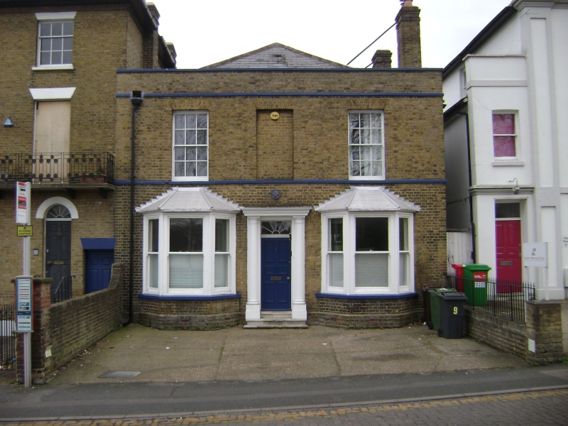
ALBION PLACE
1.
5278
(North-West Side)
No 9
TQ 7655 NE 3/189
II GV
2.
Early to mid Cl9. 2 storeys and basement, stock brick. Slate roof. Parapet
and stone coping. Eaves band and stringoourse. 2 sashes and a central blank
with glazing bars intact. The ground floor has 2 3 light bays. Central doorcase
with fluted Tuscan half columns, rectangular fanlight, panelled reveals and
6 panelled door.
Nos 7 to 21 (odd) form a group.
Listing NGR: TQ7655055826
External links are from the relevant listing authority and, where applicable, Wikidata. Wikidata IDs may be related buildings as well as this specific building. If you want to add or update a link, you will need to do so by editing the Wikidata entry.


Other nearby listed buildings
